 Filter: Categories of Wisconsin Historical Images
Filter: Subject of Marshes
Filter: Categories of Wisconsin Historical Images
Filter: Subject of Marshes

| Date: | |
|---|---|
| Description: | View across a marshy area towards a man, Mike Heberlein (of Cambridge), fishing while sitting in a wooden, ladder-back, dining chair that is submerged in t... |

| Date: | 1934 |
|---|---|
| Description: | This map shows the area as it appeared in 1848 and includes buildings, land use, and roads with distances to nearby locations. The upper right corner reads... |

| Date: | |
|---|---|
| Description: | View across water towards a man wearing a hat and hip waders sitting on a wooden chair partially submerged in the water. He is holding a fishing pole. A ma... |
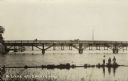
| Date: | |
|---|---|
| Description: | View from shore towards a bridge crossing a river. Three boys are standing in the marshy foreground, and one of them has a fishing pole. A horse and buggy ... |

| Date: | 1931 |
|---|---|
| Description: | This map shows heavy industrial districts (yellow), commercial and light manufacturing districts (red), and residential districts (white) as well as a plat... |

| Date: | 1931 |
|---|---|
| Description: | This photocopy map shows lot and block numbers, some landownership and acreages, water flowage, and marshes. The map also shows Lake Menomin and Wilson Cr... |

| Date: | 06 30 1895 |
|---|---|
| Description: | A man is standing in the right foreground near a tall plant, perhaps corn. In the center is a square-shaped pond with high banks. A man is in the backgroun... |

| Date: | |
|---|---|
| Description: | Elevated view from a hill of a lake or river surrounded by fields and hills. The water is either marshy, or has been flooded, as trees and plants are growi... |

| Date: | |
|---|---|
| Description: | Photograph of a framed watercolor painting of a hunter walking in tall grass among trees by the Johnson duck shack at old Cherokee Marsh. |

| Date: | |
|---|---|
| Description: | View of Johnson duck shack at old Cherokee Marsh amidst trees and shrubs. The site was where plans for the Ducks Unlimited southern Wisconsin chapter were ... |

| Date: | 1755 |
|---|---|
| Description: | This map shows the eastern half of North America during the French and Indian war, including cities, borders, Native American Land, forts, and detailed geo... |

| Date: | 1770 |
|---|---|
| Description: | Map of North America from the Great Lakes to the northern portion of South America. It shows cities, Native American land, mountains, swamps, lakes, rivers... |

| Date: | 1740 |
|---|---|
| Description: | Map including the regions and cities of the northern half of North America. Native American land, rivers, lakes, mountains are labeled. Mountains, marshes,... |

| Date: | 1718 |
|---|---|
| Description: | First edition of L'Isle's landmark map of North America. It covers America from the Rio Grande to the Atlantic Ocean, showing boundaries, the colonies, cit... |

| Date: | 1720 |
|---|---|
| Description: | Map of North America from from the Rio Grande to the Atlantic Ocean, showing boundaries, the colonies, cities, settlements, mines, forts, Native American l... |

| Date: | 1784 |
|---|---|
| Description: | Detailed and ornate map of the newly formed United States. The borders of the southern states extend to the Mississippi River, though the states are only c... |

| Date: | 1782 |
|---|---|
| Description: | Map of America covering the Rio Grande to the Atlantic Ocean, showing boundaries, the colonies, cities, settlements, Native American lands and villages, m... |

| Date: | 1792 |
|---|---|
| Description: | Map of the United States east of the Mississippi River and north of the Ohio River. It shows the borders between the north eastern states, Canada and the U... |

| Date: | 1794 |
|---|---|
| Description: | Extremely detailed map of the south-eastern states, south from Virginia and east of the Mississippi River. It shows roads and paths, cities, towns, forts, ... |

| Date: | 1795 |
|---|---|
| Description: | Heavily detailed and rare map of the United States. The map features the states, territories, cities, towns, forts, mines, mountains, swamps, lakes, and ri... |
If you didn't find the material you searched for, our Library Reference Staff can help.
Call our reference desk at 608-264-6535 or email us at: