 Filter: Categories of Wisconsin Historical Images
Filter: Subject of Marshes
Filter: Community of Green Bay
Filter: Categories of Wisconsin Historical Images
Filter: Subject of Marshes
Filter: Community of Green Bay

| Date: | 1867 |
|---|---|
| Description: | Bird's-eye map of Green Bay and Fort Howard, Brown Co., depicts street names and street layouts, houses, trees, and the East River. A reference key at the ... |
| Date: | 1898 |
|---|---|
| Description: | Caption reads: "Old Stone Tower and House, Long Tail Point, Green Bay, Wis." Water and a marshy area are in the foreground. |

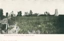
| Date: | 1905 |
|---|---|
| Description: | Long Tail Lighthouse and surrounding buildings. |
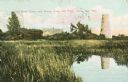
| Date: | 1910 |
|---|---|
| Description: | Caption reads: "Old Light House at Long Tail Point, Green Bay, Wis." Built in 1859. A marshy area is in the foreground, and a long pier leads to the new li... |
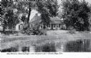
| Date: | 1907 |
|---|---|
| Description: | View across water toward the Tank Cottage. Caption reads: "The Historic Tank Cottage — over 100 years old — Green Bay, Wis." |

| Date: | 1900 |
|---|---|
| Description: | This photostat of a manuscript map originally drawn in 1829 shows landownership, buildings, including Fort Howard and U.S. sawmill, swamps, public barns an... |

| Date: | 1818 |
|---|---|
| Description: | Overhead view of the layout of the fort, with the Fox River at the top, and a "Cranberry Marsh of 1/2 mile in extent" below right. At the bottom is a rende... |
If you didn't find the material you searched for, our Library Reference Staff can help.
Call our reference desk at 608-264-6535 or email us at: