 Filter: Categories of Wisconsin Historical Images
Filter: Subject of Maps
Filter: Categories of Wisconsin Historical Images
Filter: Subject of Maps
| Date: | |
|---|---|
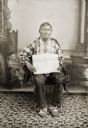
| Description: | Full-length studio portrait of an elderly Ho-Chunk man posing sitting in front of a painted backdrop. Green Grass (HaWinChoKah) is wearing floral beaded Ho... |

| Date: | 1930 |
|---|---|
| Description: | Exterior view of the Triangle filling station on Highway 12, which sold gasoline, ice, and other items. A man stands in front by the gas pump, and a map of... |
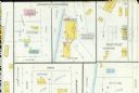
| Date: | 03 1904 |
|---|---|
| Description: | Detail of a Sanborn map of Grafton including the Sheboygan Knitting Company. |
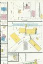
| Date: | 07 1929 |
|---|---|
| Description: | A detail of a Sanborn map of Grafton including the New York Recording Laboratory. |

| Date: | |
|---|---|
| Description: | A tinted tintype of a Civil War soldier posing with an officer's sword in front of an elaborately painted studio backdrop depicting a tent, an American fla... |

| Date: | 1977 |
|---|---|
| Description: | George McGovern photographed during an interview by Robert Novak. Behind McGovern is a desk, American flag, and a large map of the world. |

| Date: | 11 06 1980 |
|---|---|
| Description: | Magda Herzberger stands in front of a map of the United States holding a wooden plaque carved with a Star of David and the inscription, "In Gratitude to Ma... |
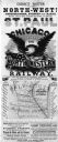
| Date: | 1853 |
|---|---|
| Description: | Poster advertising Chicago & Northwestern Railway featuring a map of the route, and an image of an eagle with a banner in its beak and an American flag. |

| Date: | 12 02 1949 |
|---|---|
| Description: | Artist Joan Holm, daughter of John and Harriet Holm of 2318 Rugby Row, painting a mural map of the city of Madison on a wall in the business offices of Mad... |
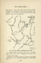
| Date: | |
|---|---|
| Description: | Hand-drawn map of the location of the Fox Indian Wars. |

| Date: | 1942 |
|---|---|
| Description: | Photographic copy of a poster made by International Harvester's advertising department to solicit funds for the International Harvester Company's World War... |
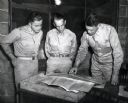
| Date: | 1942 |
|---|---|
| Description: | Three uniformed men study a map placed on a desk. The original caption reads: "STUDYING THE BATTALION'S NEXT HOME. Lt. Col. D.L. Van Syckle (right), comman... |
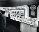
| Date: | 1944 |
|---|---|
| Description: | Men and women look at an International Harvester Company display featuring illustrations, posters, and machinery parts used in wartime work. The text in th... |
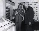
| Date: | 1944 |
|---|---|
| Description: | Charles E. Wilson, Executive Vice Chairman of the War Production Board and formerly president of General Electric Company, and Lieutenant General William S... |
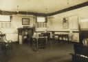
| Date: | |
|---|---|
| Description: | Interior view of the Elroy Public Library. The library opened in 1908 and was funded by Andrew Carnegie with $10,000. On the lower right the cardboard back... |
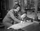
| Date: | 02 20 1950 |
|---|---|
| Description: | League of Women Voters members Elizabeth Antonius (left), 221 South Owen Drive, and Josephine Jenkins, 2805 Sylvan Avenue, study a map in preparation for a... |
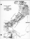
| Date: | 03 16 1950 |
|---|---|
| Description: | Map of areas surveyed by block number as part of the Madison Housing Authority Survey of Substandard Housing. |
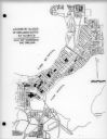
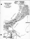
| Date: | 03 16 1950 |
|---|---|
| Description: | Map of locations by block of dwellings rated as blighted as part of the Madison Housing Authority Survey of Substandard Housing. |
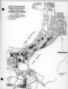
| Date: | 03 16 1950 |
|---|---|
| Description: | Map of locations of blocks of dwellings rated as slums, as part of the Madison Housing Authority Survey of Substandard Housing. |
| Date: | 03 16 1950 |
|---|---|
| Description: | Map of locations by blocks or areas of dwelling units in which violations of ordinance were apparent as part of the Madison Housing Authority Survey of Sub... |
If you didn't find the material you searched for, our Library Reference Staff can help.
Call our reference desk at 608-264-6535 or email us at: