 Filter: Categories of Wisconsin Historical Images
Filter: Subject of Maps
Filter: County of Waukesha
Filter: Categories of Wisconsin Historical Images
Filter: Subject of Maps
Filter: County of Waukesha

| Date: | 1941 |
|---|---|
| Description: | This map shows heavy and light industry, residences, and business districts as well as streets and Mill Pond. The front and back of the map include extensi... |
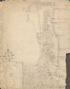
| Date: | 1929 |
|---|---|
| Description: | An unsigned, hand-drawn map of properties owned by members of the Brumder family on the northwest shore of Pine Lake in 1929. Named Villa Henrietta, the pr... |

| Date: | 06 30 1935 |
|---|---|
| Description: | Herbert Edmund Brumder standing with his sister Barbara, center, and mother, Margaret Bouer (Mrs. Herbert P.) Brumder near the dining table on the screened... |
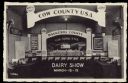
| Date: | 1940 |
|---|---|
| Description: | Text on reverse reads: "We invite you to attend Waukesha County Dairy Show. March 12-15, 1940. Sales Pavilion, Waukesha, Wis. Judging days, March 13-14. Fo... |
If you didn't find the material you searched for, our Library Reference Staff can help.
Call our reference desk at 608-264-6535 or email us at: