 Filter: Categories of Wisconsin Historical Images
Filter: Subject of Maps
Filter: County of Grant
Filter: Categories of Wisconsin Historical Images
Filter: Subject of Maps
Filter: County of Grant
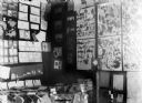
| Date: | 1913 |
|---|---|
| Description: | Exhibit featuring pressed flowers, maps, drawings, and written compositions. |
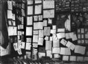
| Date: | 1913 |
|---|---|
| Description: | Exhibit featuring maps, drawings, photographs, and compositions. |
| Date: | |
|---|---|
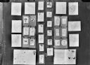
| Description: | Display of student work, including maps, drawings, and essays. |
| Date: | |
|---|---|
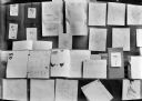
| Description: | Display of student work including drawings, maps, and essays. |
| Date: | |
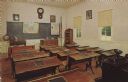
|---|---|
| Description: | Color postcard of the classroom of the Muddy Hollow School at Stonefield. Slate tablets are on the desks. |
| Date: | |
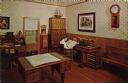
|---|---|
| Description: | Color postcard of the interior of the Law Office at Stonefield. A man is seated at the desk. |

| Date: | 1942 |
|---|---|
| Description: | This map shows a paper city laid out in 1836 on the Wisconsin River, now the site of Wyalusing State Park, Grant County. The upper right corner includes a ... |

| Date: | 11 03 1903 |
|---|---|
| Description: | A drawing of a group of burial mounds in Linden Valley. Text on back reads: "These mounds lie at the narrow mouth of Linden Valley on the east side of the ... |
If you didn't find the material you searched for, our Library Reference Staff can help.
Call our reference desk at 608-264-6535 or email us at:
