 Filter: Categories of Wisconsin Historical Images
Filter: Subject of Madeline Island (Wis.)
Filter: Categories of Wisconsin Historical Images
Filter: Subject of Madeline Island (Wis.)

| Date: | 1977 |
|---|---|
| Description: | This pictorial map was produced by the Chateau, a resort in La Pointe, and shows Madeline Island landmarks and tourist attractions. On the verso is the spr... |

| Date: | 1964 |
|---|---|
| Description: | This 1964 map of Madeline Island, Ashland County, Wisconsin, shows existing and historical locations, roads, the boundaries of a proposed state park, secti... |

| Date: | 1856 |
|---|---|
| Description: | This map shows land ownership by name, a plat of Bayfield, local streets, part of Lake Superior, part of Madeline Island, and part of Bass Island. La Point... |
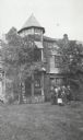
| Date: | 1910 |
|---|---|
| Description: | Group of people standing in front of Cedar Bark Lodge on (Wilson) Hermit Island, Apostle Islands. Cedar Bark Lodge was also known as the Hermitage. |
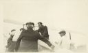
| Date: | 1918 |
|---|---|
| Description: | Men gathered around airplane. Clarence Russell? on right side. |
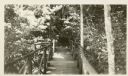
| Date: | 1915 |
|---|---|
| Description: | Wooden walkway with railings surrounded by trees. |
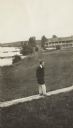
| Date: | 1913 |
|---|---|
| Description: | Jesse Stone walking on board sidewalk, with the Mission Inn along the shoreline in the background. |

| Date: | 1845 |
|---|---|
| Description: | This map shows lakes, rivers, Chippewa land, the U.S. Mineral Land Agency, boundary between U.S. and Canada, Methodist and Catholic missions, and American ... |

| Date: | 1847 |
|---|---|
| Description: | This map identifies surveyed areas of the Upper Peninsula and shows lakes, rivers, and islands in portions of Wisconsin, Minnesota, Michigan, and upper Can... |

| Date: | 1959 |
|---|---|
| Description: | This map shows landownership, acreages, and old fort road on the southwest corner of Madeline Island. The map includes an explanation of survey in the midd... |

| Date: | 08 1971 |
|---|---|
| Description: | Aerial view of Madeline Island, and a few of the Apostle Islands in the distance. |

| Date: | 07 1936 |
|---|---|
| Description: | Wooden roof-like grave covers and fences mark the graves in a Madeline Island cemetery. There is also a wooden cross on the right. Originally named St. Jo... |
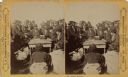
| Date: | 1870 |
|---|---|
| Description: | Ojibwa Indians receiving annuity payment. Seated on the right is John W. Bell. Others are, left to right, Asaph Whittlesey, Agent Henry C. Gilbert, and Wil... |
If you didn't find the material you searched for, our Library Reference Staff can help.
Call our reference desk at 608-264-6535 or email us at:
