 Filter: Categories of Wisconsin Historical Images
Filter: Subject of Locks (Hydraulic engineering)
Filter: Categories of Wisconsin Historical Images
Filter: Subject of Locks (Hydraulic engineering)
| Date: | |
|---|---|
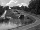
| Description: | Five combined locks between the Hudson River and Lake Champlain in a wooded area. A dirt road runs along one side and a stepped concrete stream-bed runs a... |

| Date: | |
|---|---|
| Description: | A boat entering a hydraulic lift lock located in Peterborough, Ontario, Canada. The lock structure is an imposing series of steel and concrete towers with ... |

| Date: | |
|---|---|
| Description: | A boat entering a hydraulic lift lock located in Peterborough, Ontario, Canada. The lock structure is an imposing series of steel and concrete towers, with... |

| Date: | |
|---|---|
| Description: | A boat half way up a hydraulic lift lock located in Peterborough, Ontario, Canada. The lock structure is an imposing series of steel and concrete towers, w... |

| Date: | |
|---|---|
| Description: | A hydraulic lift lock with a boat at a full vertical elevation of 66 feet in Peterborough, Ontario, Canada. The lock structure is an imposing series of ste... |
| Date: | 1904 |
|---|---|
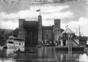
| Description: | Official opening of the sixty-six foot Peterboro hydraulic lift lock, built in 1904 on the Trent Canal. People gather in boats and along the shore to celeb... |

| Date: | |
|---|---|
| Description: | Profile view of the sixty-six foot Peterboro hydraulic lift lock, built in 1904 on the Trent Canal. People gather on the top of the lock. The lift lock is ... |

| Date: | |
|---|---|
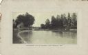
| Description: | View along the right side of the third lock and draw bridge spanning the Fox River. Caption reads: "Third Lock and Draw Bridge, Appleton, Wis." |
| Date: | |
|---|---|
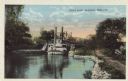
| Description: | Colorized postcard of a steamboat passing through the canal lock along the Fox River. Caption reads: "Canal Lock, Appleton, Wis." |
| Date: | |
|---|---|
| Description: | Postcard of the government lock along the Fox River in Kimberly. A house and fence are along the shoreline to the left. Caption reads: "Government Lock at ... |
| Date: | 12 23 1905 |
|---|---|
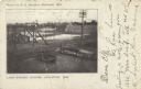
| Description: | Elevated view of Lake Street bridge and nearby locks along the Fox River. Caption reads: "Lake Street Bridge, Appleton, Wis." |
| Date: | 1856 |
|---|---|
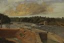
| Description: | "The second view at the Kakalin, from the north side of the river, shows the first or guard lock in the foreground and beyond the dam the large frame build... |
| Date: | 1856 |
|---|---|
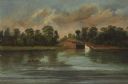
| Description: | "Three views in a short space show the peaceful appearance of what is now a busy paper mills center. The first, a double lock around which the village of C... |

| Date: | 1856 |
|---|---|
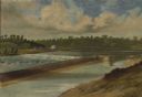
| Description: | "....The third view was twelve miles farther up the river [from De Pere], at Rapid Croche, on the border of the present Brown and Outagamie counties. It is... |
| Date: | 1856 |
|---|---|
| Description: | " . . . At Grand Chute stood the young settlement of Appleton. Although only a few years old, it already boasted a college, named, as was the village itsel... |

| Date: | 1873 |
|---|---|
| Description: | Engraved image of a lock and dam at Sault St. Marie. Two men are operating the sluice as ships are waiting on the opposite side of the lock. Another man is... |

| Date: | 08 17 1874 |
|---|---|
| Description: | This manuscript drawing provides a side elevation, plan, and perspective view for a proposed lock on the Fox River. |

| Date: | 1892 |
|---|---|
| Description: | This map shows the dams and locks of the Fox River between Neenah, in Winnebago County, Wisconsin, and Kaukauna, in Outagamie County. The cities and villag... |

| Date: | 1868 |
|---|---|
| Description: | Map showing the northern water routes between Mississippi River and Atlantic Ocean Relief shown by hachures. Includes Profile of the Erie Canal, table of ... |

| Date: | 1875 |
|---|---|
| Description: | This map, from G.K. Warren's 1876 Report on the transportation route along the Wisconsin and Fox Rivers in the State of Wisconsin between the Mississippi R... |
If you didn't find the material you searched for, our Library Reference Staff can help.
Call our reference desk at 608-264-6535 or email us at: