Filter: Categories of Wisconsin Historical Images
Filter: Subject of Landscape
Filter: County of Dane
Filter: Categories of Wisconsin Historical Images
Filter: Subject of Landscape
Filter: County of Dane

| Date: | 1873 |
|---|---|
| Description: | Main Street, with its dirt, ruts, cows (and presumably manure), but wide enough for easy hitching of wagons and teams. |

| Date: | 1862 |
|---|---|
| Description: | Camp Randall looking southwest. In April 1861, Governor Alexander Randall asked that the State Agricultural Society fairgrounds be converted into a militar... |
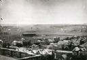
| Date: | 1906 |
|---|---|
| Description: | Elevated view of Camp Randall Field from the top of Bascom Hall, with University Heights in the background. A crowd is in the stands at the stadium, and a ... |

| Date: | 1893 |
|---|---|
| Description: | Back of painting reads: "Madison in June 1837 after photo taken by E.E. Bailey" and "Peck's cabin by Dengel." The Eben Peck cabin was the first house built... |

| Date: | |
|---|---|
| Description: | The Eben Peck cabin was the first house built in Madison. |

| Date: | 06 1837 |
|---|---|
| Description: | Lithograph based on a painting by Mrs. E.E. Bailey showing the Peck cabin, the first house in Madison. In addition to the cabin, the lithograph includes a ... |
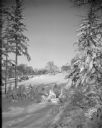
| Date: | 03 27 1928 |
|---|---|
| Description: | Winter scene with Agriculture Hall, covered with snow, on the University of Wisconsin-Madison campus. Agriculture Hall is in the distance. |
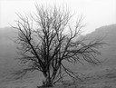
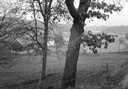
| Date: | 10 20 1963 |
|---|---|
| Description: | Bare tree, complemented by birches in bright fall foliage, in the vicinity of Highway J, south. |
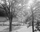
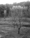
| Date: | 06 25 1964 |
|---|---|
| Description: | Trees in the valley against the sun, below Stewart Park. |

| Date: | 12 01 1962 |
|---|---|
| Description: | A farm road between fields in late sunlight, looking towards Mounds Creek in the vicinity of CTH F. |
| Date: | 12 01 1962 |
|---|---|
| Description: | A valley and farm in the vicinity of Highway F to the west. |
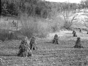
| Date: | 11 06 1960 |
|---|---|
| Description: | A corner of a cornfield in an early snow. |
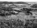
| Date: | 07 23 1960 |
|---|---|
| Description: | A view from bluffs, looking south, in the vicinity of Highway 78. |
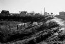
| Date: | 10 03 1960 |
|---|---|
| Description: | Early morning at a railroad crossing on County Highway A, with houses and a barn in the distance. |

| Date: | 1879 |
|---|---|
| Description: | Bird's-eye view of Wisconsin State University, now the University of Wisconsin-Madison. Vignettes include Ladies Hall, South Dormitory, University Hall, As... |

| Date: | 1852 |
|---|---|
| Description: | Pencil drawing of Madison landscape as seen from University Hill. The main street in the center is State Street, and the building with Greek columns in the... |

| Date: | 1852 |
|---|---|
| Description: | Pencil drawing of view overlooking Madison. The sketch looks down North Hamilton Street from the capitol. Rutted, irregular streets and frame houses mark ... |

| Date: | 1875 |
|---|---|
| Description: | Bird's-eye map of Mazomanie. |
If you didn't find the material you searched for, our Library Reference Staff can help.
Call our reference desk at 608-264-6535 or email us at: