 Filter: Categories of Wisconsin Historical Images
Filter: Subject of Land use, Urban
Filter: Creator Name of Vinje, Arthur M., 1888-1972
Filter: Categories of Wisconsin Historical Images
Filter: Subject of Land use, Urban
Filter: Creator Name of Vinje, Arthur M., 1888-1972

| Date: | 06 15 1948 |
|---|---|
| Description: | Uncollected garbage on South Hamilton Street being viewed by two children during a walkout strike by Local 236 Municipal Garage Department Union. |
| Date: | |
|---|---|
| Description: | Aerial view looking northeast towards the east side of Madison between Lake Monona and Lake Mendota, from Blair Street to the Yahara River. |
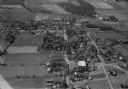
| Date: | 10 1928 |
|---|---|
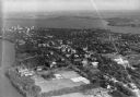
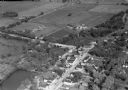
| Description: | Aerial view of DeForest including residences and the surrounding countryside. |
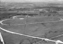
| Date: | 1930 |
|---|---|
| Description: | Aerial view of the Dane County fairgrounds, including several buildings and a track. |

| Date: | 11 1928 |
|---|---|
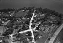
| Description: | Aerial view of Verona including businesses, houses, and the surrounding farm land. |
| Date: | 11 1928 |
|---|---|
| Description: | Aerial view of Middleton including businesses, residences, the railroad tracks, and the surrounding countryside. |
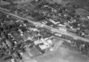
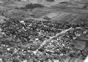
| Date: | 1930 |
|---|---|
| Description: | Aerial view of the town, including business, houses, and railroad tracks cutting through the town. |
| Date: | 1930 |
|---|---|
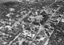
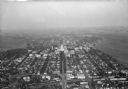
| Description: | Aerial view looking southeast, towards the city, including the Wisconsin State Capitol, the central business district, the Capitol Square, both Lake Mendot... |
| Date: | |
|---|---|
| Description: | Aerial view of downtown area featuring the Wisconsin State Capitol. |
| Date: | 11 1928 |
|---|---|
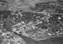
| Description: | Aerial view of Stoughton including the central business district, the Yahara River, and the surrounding countryside. |

| Date: | 1930 |
|---|---|
| Description: | Aerial view of the University of Wisconsin-Madison campus, the State Historical Society of Wisconsin building, Lake Mendota, residential areas and the surr... |
| Date: | |
|---|---|
| Description: | Aerial view of the town, including the Wisconsin River, and the surrounding countryside. |
| Date: | 10 1928 |
|---|---|
| Description: | Aerial view of Belleville, including the central business disctrict and the surrounding countryside. |
| Date: | 1930 |
|---|---|
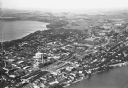
| Description: | Aerial view of the city and the Isthmus, the Wisconsin State Capitol, the downtown business district, and both Lake Mendota and Lake Monona. |
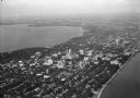
| Date: | 1930 |
|---|---|
| Description: | Aerial view of the city, including the Isthmus, the Wisconsin State Capitol, the downtown business district, Lake Mendota, and Lake Monona. |

| Date: | 10 1928 |
|---|---|
| Description: | Aerial view of Sun Prairie, including the central business district, residences, and the surrounding countryside stretching to the horizon. |
| Date: | 10 1928 |
|---|---|
| Description: | Aerial view of Sun Prairie, including the central business district, residences, and the surrounding countryside. |

| Date: | 1930 |
|---|---|
| Description: | Aerial view of the Wisconsin State Capitol, the surrounding businesses, and Lake Monona. |

| Date: | 1930 |
|---|---|
| Description: | Aerial view of the Wisconsin State Capitol and the surrounding businesses. |

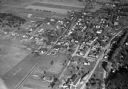
| Date: | 10 1928 |
|---|---|
| Description: | Aerial view of Mount Horeb, including the central business district. |
If you didn't find the material you searched for, our Library Reference Staff can help.
Call our reference desk at 608-264-6535 or email us at: