 Filter: Categories of Wisconsin Historical Images
Filter: Subject of Land
Filter: Year of 1600-1699
Filter: Categories of Wisconsin Historical Images
Filter: Subject of Land
Filter: Year of 1600-1699

| Date: | 1697 |
|---|---|
| Description: | Father Hennepin's map in French of the upper lakes. |
| Date: | 1671 |
|---|---|
| Description: | Photostat of map of Lac Tracy Ou Superieur (Lake Superior). Portions of Lac des Illinois (Lake Michigan) and Lac des Hurons (Lake Huron) are also shown. Gr... |

| Date: | 1655 |
|---|---|
| Description: | Map of Virginia Coast based on observations by Captain John Smith. |
| Date: | 1655 |
|---|---|
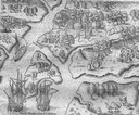
| Description: | Scene from the Laudonnière Expedition in South Carolina, ca. 1564. |
| Date: | 1655 |
|---|---|
| Description: | Scene from Laudonnière Expedition in Florida, ca. 1567. |

| Date: | 1655 |
|---|---|
| Description: | Map from Drake Expedition, ca. 1585. |

| Date: | 1655 |
|---|---|
| Description: | Map from Drake Expedition in Florida, ca. 1585. |
| Date: | 1655 |
|---|---|
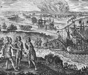
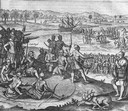
| Description: | Scene from Jamestown Settlement in Virginia, 1610. |
| Date: | 1655 |
|---|---|
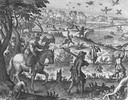
| Description: | Scene from Jamestown Settlement in which the brothers of Pocahontas visit her. |
| Date: | 1655 |
|---|---|
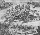
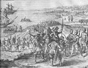
| Description: | Scene from near Jamestown Settlement in Virginia, ca. 1614. The Chickahominy tribe's proximity to Jamestown meant they had early contact with the English.... |
| Date: | 1655 |
|---|---|
| Description: | Scene from near Jamestown Settlement, ca. 1620. |

| Date: | 1632 |
|---|---|
| Description: | The Wisconsin portion of Champlain's 1632 map, augmented since the previous one, for navigation according to the true Meridien, by Sieur de Champlain. The ... |

| Date: | 1670 |
|---|---|
| Description: | This map is in French and shows Lac Tracy ov Superieur (Lake Superior), Baye des Puans (Green Bay), and portions of Lac des Ilinois (Lake Michigan) and Lac... |

| Date: | 1673 |
|---|---|
| Description: | P. Marquette en Joliet, gedan in't jaar 1673. |

| Date: | 1673 |
|---|---|
| Description: | Facsimile of the autograph map of the Mississippi or Conception River drawn by Father Marquette at the time of his voyage. From the original preserved at S... |
| Date: | 1610 |
|---|---|
| Description: | A map of New France, including parts of the United States and Canada, to illustrate the Jesuit relations and allied documents. There is some handwriting an... |
| Date: | 1610 |
|---|---|
| Description: | A map of New France, including parts of the United States and Canada, to illustrate the Jesuit relations and allied documents. |

| Date: | 1695 |
|---|---|
| Description: | Copperplate engraving; Venice, 1695. Scale [ca. 1:5,069,000] at center. |

| Date: | 1698 |
|---|---|
| Description: | Copperplate engraving. Scale [ca. 1:11,500,00]. |
If you didn't find the material you searched for, our Library Reference Staff can help.
Call our reference desk at 608-264-6535 or email us at:
