 Filter: Categories of Wisconsin Historical Images
Filter: Subject of Land
Filter: Categories of Wisconsin Historical Images
Filter: Subject of Land
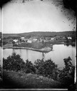
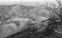
| Date: | 1875 |
|---|---|
| Description: | A view of the village from a nearby bluff across a pond. Men, women and children, standing spaced apart, are posing in the field near the pond. |

| Date: | 1886 |
|---|---|
| Description: | Bird's-eye view of Ashland, on the shores of Lake Superior, with insets of The Apostle Islands Chequamagon Bay & Ashland, and Distances from Ashland. |

| Date: | 1856 |
|---|---|
| Description: | This map show the surveyed southern part of state and includes "profile of the Milwaukee and Mississippi Rail Road." Counties are shown in pink, green, blu... |
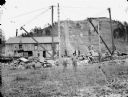
| Date: | 1894 |
|---|---|
| Description: | Men loading rock from Saddle Mound quarry onto a St. Paul Railroad flat car. |
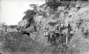
| Date: | 1900 |
|---|---|
| Description: | Visitors, dressed in their Sunday best, contrast with the rough garb of the miners. Left to right, miners were: Charles Kanass, Robert "Beaver" Smith (hold... |

| Date: | 06 1837 |
|---|---|
| Description: | Lithograph based on a painting by Mrs. E.E. Bailey showing the Peck cabin, the first house in Madison. In addition to the cabin, the lithograph includes a ... |
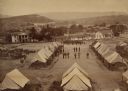
| Date: | 1864 |
|---|---|
| Description: | Elevated view of Battery C, 1st Regiment, Wisconsin Heavy Artillery at Fort Sherman, shown here after the battles of Missionary Ridge and Lookout Mountain.... |

| Date: | 1898 |
|---|---|
| Description: | Old Mission Residence at La Pointe, Madeline Island. |
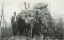
| Date: | |
|---|---|
| Description: | Group of Native Americans-Potowatomi standing in front of rock formation. |

| Date: | 1821 |
|---|---|
| Description: | Indians of the North Red River area, probably in the vicinity of old Fort Douglas, now Winnipeg, Canada, spearing beaver. |

| Date: | 10 1829 |
|---|---|
| Description: | Fort Crawford as drawn by Seth Eastman. People are in a canoe in the river in the foreground. Across the river is the fort, other buildings around the fort... |

| Date: | 1835 |
|---|---|
| Description: | Little Lake Butte Des Morts just north of Lake Winnebago where Governor Lewis Cass of Michigan, and Thomas McKenney, head of the Bureau of Indian Affairs (... |

| Date: | 1899 |
|---|---|
| Description: | A studio portrait of naturalist, conservationist, and writer John Muir. |
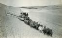
| Date: | 09 18 1923 |
|---|---|
| Description: | Harvester-Thresher (combine) on a hill in a field drawn by a team of eleven horses. |
| Date: | 1913 |
|---|---|
| Description: | Elevated view of Taliesin. Taliesin is located in the vicinity of Spring Green. |

| Date: | |
|---|---|
| Description: | Forest destroyed by destructive logging followed by a fire. The right-hand side of the image shows where soil erosion has begun. |
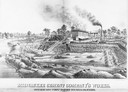
| Date: | 1880 |
|---|---|
| Description: | Lithograph of the Milwaukee Cement Company's Works at 154 West Water Street in Milwaukee. |
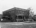
| Date: | 1909 |
|---|---|
| Description: | Exterior view of the front and side of the Wisconsin House. |
If you didn't find the material you searched for, our Library Reference Staff can help.
Call our reference desk at 608-264-6535 or email us at:

