 Filter: Categories of Wisconsin Historical Images
Filter: Subject of Jewelry
Filter: Year of 1700-1799
Filter: Categories of Wisconsin Historical Images
Filter: Subject of Jewelry
Filter: Year of 1700-1799
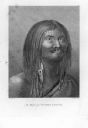
| Date: | 1784 |
|---|---|
| Description: | Plate 38. Portrait from Cook's Third Expedition, 1776-1779, while in Alaska. |
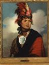
| Date: | 1786 |
|---|---|
| Description: | Print of a Gilbert Stuart painted portrait of Thayendangea (known also as Joseph Brant). He wears a feathered headdress and a shell around his neck. |

| Date: | 1780 |
|---|---|
| Description: | Map of North and South America, showing the boundaries of colonial territories, cities, settlements, rivers, lakes, and Native American land. Particular em... |

| Date: | 1770 |
|---|---|
| Description: | Map of North America from the Great Lakes to the northern portion of South America. It shows cities, Native American land, mountains, swamps, lakes, rivers... |
If you didn't find the material you searched for, our Library Reference Staff can help.
Call our reference desk at 608-264-6535 or email us at: