Filter: Categories of Wisconsin Historical Images
Filter: Subject of Islands
Filter: Categories of Wisconsin Historical Images
Filter: Subject of Islands
| Date: | 1929 |
|---|---|
| Description: | One of the four harbors on Washington Island. There is a man on a pier or dock in the foreground, and a boat approaching on the left. A tree-lined shorelin... |
| Date: | 1910 |
|---|---|
| Description: | View of Sawyer Harbor as seen from Government Bluff. |

| Date: | 1907 |
|---|---|
| Description: | The Ruins of the old Light House on Plum Island near Sturgeon Bay. Caption at bottom reads: "Ruins of Old Light House on Plum Island," "Made expressly for ... |
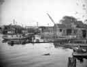
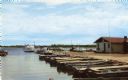
| Date: | 10 28 1938 |
|---|---|
| Description: | Docks and shanties at Jones Island, with smokestacks and cranes in the background. |
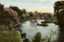
| Date: | 1905 |
|---|---|
| Description: | View from shoreline towards a river with a dam in the distance. Caption reads: "River Scene, Mayville, Wis." |
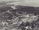
| Date: | 1955 |
|---|---|
| Description: | Aerial view of "the island" with the Marathon Corporation paper mills. The Fox River flowing out of Lake Winnebago separates the two cities, Neenah and Men... |

| Date: | |
|---|---|
| Description: | A drawing from Harney's "History of Winnebago County" of E.L. Mathewson's home on Doty Island. |

| Date: | 05 24 1896 |
|---|---|
| Description: | Rocky Roost, a cottage designed by Frank Lloyd Wright for his friend Robert Lamp. Located west of Governor's Island in Lake Mendota. |
| Date: | 1915 |
|---|---|
| Description: | Rocky Roost, a vacation home west of Governor's Island, in Lake Mendota. Frank Lloyd Wright served as the architect in the remodeling (in 1901 and 1903) of... |

| Date: | |
|---|---|
| Description: | View across Lake Mendota of Rocky Roost, also known as the Lamp Cottage, located west of Governor's Island. |

| Date: | 1905 |
|---|---|
| Description: | Rocky Roost, the Lamp family cottage, located west of Governor's Island in Lake Mendota, decorated for a party. Shown from the left are Matilda Lamp Lueder... |

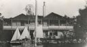
| Date: | 1948 |
|---|---|
| Description: | View from a pier of rowboats and a cabin at the Island Resort on Lake Ripley. |

| Date: | 1769 |
|---|---|
| Description: | Manuscript map. Scale: about 80 British statue miles to 1 inch. |
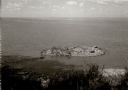
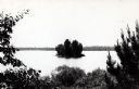
| Date: | 1963 |
|---|---|
| Description: | Elevated view of a small island near the Green Bay shore. |

| Date: | 1820 |
|---|---|
| Description: | A manuscript map of Prairie du Chien. |

| Date: | 1840 |
|---|---|
| Description: | This map surveyed under the direction of Captain Thomas J. Cram is one in a series of seventeen that accompanied Cram's report on the Fox-Wisconsin river s... |

| Date: | 1840 |
|---|---|
| Description: | This map, one of a series made by Thomas Jefferson Cram of the U.S. Topographical Engineers from personal surveys, shows the portage connecting the Wiskons... |
If you didn't find the material you searched for, our Library Reference Staff can help.
Call our reference desk at 608-264-6535 or email us at: