 Filter: Categories of Wisconsin Historical Images
Filter: Subject of Islands
Filter: County of Winnebago
Filter: Categories of Wisconsin Historical Images
Filter: Subject of Islands
Filter: County of Winnebago
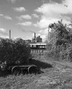
| Date: | 09 29 1963 |
|---|---|
| Description: | The Menasha Woodenware plant and water tower on Doty Island from across the Fox River canal, with a small railroad dolly in the foreground. |
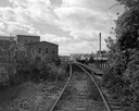
| Date: | 09 29 1963 |
|---|---|
| Description: | View down railroad tracks towards the railroad bridge, with industrial plants on Doty Island. |
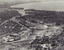
| Date: | 1955 |
|---|---|
| Description: | Aerial view of "the island" with the Marathon Corporation paper mills. The Fox River flowing out of Lake Winnebago separates the two cities, Neenah and Men... |
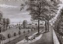
| Date: | |
|---|---|
| Description: | A drawing from Harney's "History of Winnebago County" of E.L. Mathewson's home on Doty Island. |

| Date: | 1840 |
|---|---|
| Description: | This map surveyed under the direction of Captain Thomas J. Cram is one in a series of seventeen that accompanied Cram's report on the Fox-Wisconsin river s... |

| Date: | 1910 |
|---|---|
| Description: | Doty's Loggery. Caption printed under image reads: "Governor James Duane Doty, in 1845, built this log house on Doty's Island (Menasha), and resided there ... |

| Date: | 1881 |
|---|---|
| Description: | Ink, watercolor, and pencil on paper. Top of the map reads: "NORTHERN OUTLET MENASHA MEANDER LINES Scale 132ft 1 INCH Var S.E. Survey Completed Spet. 23 18... |

| Date: | 08 24 1899 |
|---|---|
| Description: | Pen-and-ink and color on paper. Also shows probable routes of the French explorers Constant le Marchand de Lignery in 1728 and Louis de la Porte de Louvign... |

| Date: | 1876 |
|---|---|
| Description: | This map is of the towns of Neenah and Menasha and shows existing and proposed canals. Water depths shown by soundings. Little Butte des Morts Lake, Doty I... |

| Date: | 1881 |
|---|---|
| Description: | This map is pen and ink on paper and shows part of the city of Menasha, local streets, Dendo Island, part of Lake Winnebago, and part of Little Lake Butte ... |

| Date: | 1857 |
|---|---|
| Description: | This map shows lot and block numbers, streets, railroad depots, locks, bridges, dams, canals, U.S. light house, college grounds, a steam boat landing, and ... |
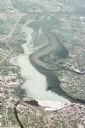
| Date: | 05 18 1970 |
|---|---|
| Description: | Aerial view titled "Neenah Pollution." The view is looking north from over Neenah at Little Lake Butte des Morts which is discolored. |
If you didn't find the material you searched for, our Library Reference Staff can help.
Call our reference desk at 608-264-6535 or email us at:
