 Filter: Categories of Wisconsin Historical Images
Filter: Subject of Islands
Filter: County of La Crosse
Filter: Categories of Wisconsin Historical Images
Filter: Subject of Islands
Filter: County of La Crosse

| Date: | 1955 |
|---|---|
| Description: | Aerial view of La Crosse, with Onalaska in the background. The highway is U.S. Highway 53 and the State Highway 35. |

| Date: | |
|---|---|
| Description: | A map of La Crosse, Wisconsin and La Crescent, Minnesota, showing sectional divisions along the shore and islands of the Mississippi River. The areas also ... |

| Date: | 1880 |
|---|---|
| Description: | This map of La Crosse shows the Chicago, Milwaukee and St. Paul Railroad, the Southern Minnesota Railroad and the Chicago, Dubuque and Minnesota Railroad, ... |

| Date: | 1891 |
|---|---|
| Description: | This map of La Crosse shows eighteen city wards in red, railroads, cemeteries, fair grounds, labeled streets, islands, and the Mississippi River. The left ... |

| Date: | 1893 |
|---|---|
| Description: | This map of La Crosse shows wards 1-20, streets, railroads, the Inter State Fair Grounds, islands, and the Mississippi River. Relief is shown by hachures. ... |

| Date: | 1940 |
|---|---|
| Description: | This map of La Crosse shows different types of land zoning: residence, multiple dwelling, local business, commercial, light industrial, heavy industrial, w... |

| Date: | 1950 |
|---|---|
| Description: | This map is intended for tourists visiting La Crosse. The front of the map provides extensive text on attractions and activities in La Crosse while the bac... |

| Date: | 1859 |
|---|---|
| Description: | This map show plats including plat names, plat numbers, and some lot owner's names. Relief is shown by hachures. The map includes line drawings of Juneau B... |

| Date: | 1857 |
|---|---|
| Description: | This map shows section corners, quarter section corners, foundry, steam saw mill, steam grist mill, planning mill, court house, baptist church, congregatio... |

| Date: | |
|---|---|
| Description: | A bathing beach on an island near a bridge, with people in the water and on the beach within an enclosed area. A canoe and rowboat are pulled up on the sho... |
| Date: | 1951 |
|---|---|
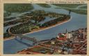
| Description: | Aerial view of a highway bridge crossing the Mississippi River and French Island. Caption reads: "New Bridge over Mississippi River, La Crosse, Wis." |
| Date: | |
|---|---|
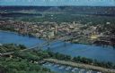
| Description: | Photographic postcard of an aerial view over La Crosse and the I-90 Interstate bridge. French Island is in the foreground. |

| Date: | |
|---|---|
| Description: | Hand-colored view of the entrance to Oehler's Cave. A group of people are gathered on an island in the stream at the mouth of the cave. Caption reads: "Oeh... |

| Date: | |
|---|---|
| Description: | View along unpaved drive, bordered by lawn and trees. In the background on the right is a bridge over the river. Caption reads: "Pettibone Drive, Lovers' L... |
| Date: | |
|---|---|
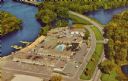
| Description: | Aerial view of the Holiday Inn, between La Crosse on Barron Island in the beautiful Mississippi. A curved road is leading to a bridge across the Mississipp... |
If you didn't find the material you searched for, our Library Reference Staff can help.
Call our reference desk at 608-264-6535 or email us at:
