 Filter: Categories of Wisconsin Historical Images
Filter: Subject of Islands
Filter: County of Crawford
Filter: Categories of Wisconsin Historical Images
Filter: Subject of Islands
Filter: County of Crawford
| Date: | |
|---|---|
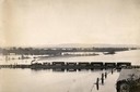
| Description: | Elevated view of the pile-pontoon railroad bridge across the Mississippi River at Prairie du Chien. The bridge was built and patented by John Lawler in 187... |

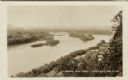
| Date: | 1902 |
|---|---|
| Description: | River with distant hills behind a town. An island is in the foreground. |

| Date: | 1820 |
|---|---|
| Description: | A manuscript map of Prairie du Chien. |
| Date: | 1960 |
|---|---|
| Description: | Aerial view of Villa Louis on the Mississippi River, and adjacent buildings. |
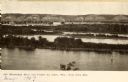
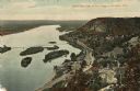
| Date: | 1905 |
|---|---|
| Description: | View looking toward old Diamond Jo Warehouse, before the bridge was built. Caption reads: "Mississippi River and Prairie du Chien, Wis., from Iowa Side". |
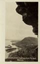
| Date: | 1910 |
|---|---|
| Description: | View from the bluffs in or near McGregor, Iowa. A fence and trees are in the foreground. |

| Date: | 1828 |
|---|---|
| Description: | Plat of the Private Claims at Prairie Du Chien. |
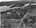
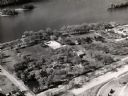
| Date: | 03 28 1949 |
|---|---|
| Description: | Aerial view of Prairie du Chien showing the Mississippi River in the background. |
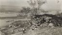
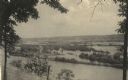
| Date: | 1915 |
|---|---|
| Description: | Elevated view of the Mississippi River from a bluff. There is a farm and other houses along the shoreline, and in the foreground a boy stands on the bluff ... |
| Date: | 1910 |
|---|---|
| Description: | Color enhanced aerial view of the village of DeSoto, looking north along the Mississippi River. Caption reads: "Bird's Eye View of the Village of De Soto, ... |
| Date: | 1920 |
|---|---|
| Description: | Black and white photographic postcard view of De Soto, taken from the cliff south of town, looking north along the Mississippi River. Caption reads: "A Vie... |
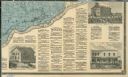
| Date: | 1878 |
|---|---|
| Description: | The bottom right corner of a map of Crawford County. This portion of the map includes town directories and illustrations of the Court House in Prairie Du C... |

| Date: | 1900 |
|---|---|
| Description: | This photocopy map shows marshes, woods, buildings, and selected features including islands, mounds, old Fort Crawford, and "new site for a fort in questio... |

| Date: | 1942 |
|---|---|
| Description: | This photocopy plat map represents the relative position and size of the sloughs and islands in the Mississippi River, opposite Prairie du Chien. |
| Date: | |
|---|---|
| Description: | Elevated view of the Mississippi River at Lynxville. Railroad tracks are running alongside the shoreline. Caption reads: "Looking N.W. from Lynxville, Wis.... |
If you didn't find the material you searched for, our Library Reference Staff can help.
Call our reference desk at 608-264-6535 or email us at: