 Filter: Categories of Wisconsin Historical Images
Filter: Subject of Great Plains
Filter: Categories of Wisconsin Historical Images
Filter: Subject of Great Plains

| Date: | 1688 |
|---|---|
| Description: | This map includes vignettes of Amerindian life with text describing geography, culture, and exploration activity, written in French. The Great Lakes, river... |
| Date: | |
|---|---|
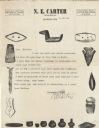
| Description: | Letterhead of N.E. Carter of Elkhorn, Wisconsin, a dealer in Indian relics and other curios from around the world, with images of individual artifacts, suc... |

| Date: | 06 1879 |
|---|---|
| Description: | Tracing of a cave petroglyph depicting a human figure wearing headgear. A club is depicted to the right of the figure. |
| Date: | 06 1879 |
|---|---|
| Description: | Tracing of a petroglyph depicting an animal figure pursued by a human figure with a bow and arrow followed by a child. |

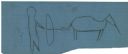
| Date: | 06 1879 |
|---|---|
| Description: | Tracing of a petroglyph depicting an animal that has been shot with an arrow. |
| Date: | 03 04 1902 |
|---|---|
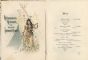
| Description: | Souvenir menu from the banquet in honor of H.R.H. Prince Henry of Prussia given by the citizens of Milwaukee at the Hotel Pfister. On the cover is a waterc... |
| Date: | 1834 |
|---|---|
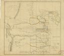
| Description: | This map shows the locations of Indian tribes, and lands sold and ceded, as well as roads, forts, and rivers. Lands in the Great Plains are covered, and Ar... |

| Date: | 1942 |
|---|---|
| Description: | This pictorial bird's-eye-view map shows the United States of America with parts of Canada and Mexico. Landscape, trade, industry, points of interest, peop... |

| Date: | 1946 |
|---|---|
| Description: | This map shows scenes from America's history with names of historical events superimposed on a map of the United States. |
| Date: | 1949 |
|---|---|
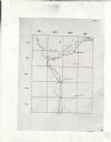
| Description: | This map is comprised of six plates that depict the rout the Sauks and Meskwakis, led by Black Hawk, took through Wisconsin during the Black Hawk War of 18... |

| Date: | 1718 |
|---|---|
| Description: | This map shows the Mississippi River, with latitude and longitude coordinates, ad covers east to Lake Ontario and south to Illinois. The inset map (the top... |

| Date: | 1720 |
|---|---|
| Description: | Map showing the course of the Mississippi River from the Gulf of Mexico up past Lake Superior into Canada. It shows the towns, Native American tribes and l... |
If you didn't find the material you searched for, our Library Reference Staff can help.
Call our reference desk at 608-264-6535 or email us at: