 Filter: Categories of Wisconsin Historical Images
Filter: Subject of Graves
Filter: Type of Map or Atlas
Filter: Categories of Wisconsin Historical Images
Filter: Subject of Graves
Filter: Type of Map or Atlas

| Date: | |
|---|---|
| Description: | Pen and ink tracing showing the positions of Union and Confederate soldiers, troop camps, location of graves, roads, drainage, vegetation, houses, and fenc... |

| Date: | 1915 |
|---|---|
| Description: | This 1915 map covers portions of Barron, Chippewa, and Rusk counties in Wisconsin. Shown are the township and range grid, sections, cities and villages, ra... |
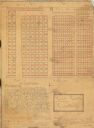
| Date: | 1929 |
|---|---|
| Description: | This 1929 survey of Meadow Creek Cemetery in the Town of Stanley, Barron County, Wisconsin, shows cemetery plots bordered by U.S. Route 53 (now County SS) ... |
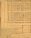
| Date: | 1929 |
|---|---|
| Description: | This 1929 survey of Rice Creek Cemetery in the Town of Stanley, Barron County, Wisconsin, shows cemetery plots without owners' names. Text of surveyor's an... |
If you didn't find the material you searched for, our Library Reference Staff can help.
Call our reference desk at 608-264-6535 or email us at: