Filter: Categories of Wisconsin Historical Images
Filter: Subject of Fortification
Filter: Categories of Wisconsin Historical Images
Filter: Subject of Fortification

| Date: | |
|---|---|
| Description: | Exterior of Fort Donelson with landscape including sparse buildings and trees. |

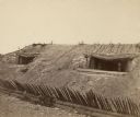
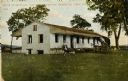
| Date: | |
|---|---|
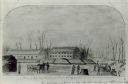
| Description: | "Hospital and (indecipherable) during the last days battle at Fort Donelson on the Tennessee." Building with people and several trees. |

| Date: | |
|---|---|
| Description: | A hand-drawn map of the state of Missouri with a separate drawing of a map showing Forts Henry and Donelson. The Missouri map includes Jefferson City and s... |
| Date: | 1862 |
|---|---|
| Description: | Fort Lincoln, Kansas, when the 12th Wisconsin Volunteers arrived on their march from Fort Scott to Lawrence. A watercolor by John Gaddis of Company E. |
| Date: | |
|---|---|
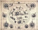
| Description: | A lithograph of eight major generals of the Union with battle scenes decorating the center. |
| Date: | |
|---|---|
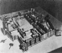
| Description: | Replica of Fort Michilimackinac, also called Mackinac. |

| Date: | |
|---|---|
| Description: | Sketch of the Fort at Michilimackinac (also called Mackinac) as it was under French rule. |
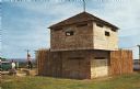
| Date: | 1960 |
|---|---|
| Description: | View of a stockade and blockhouse replica built on the site of the original stockade erected in 1862 during a small Sioux Indian uprising in nearby Minneso... |
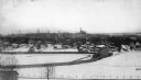
| Date: | 1898 |
|---|---|
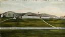
| Description: | Camp Randall, with the old stadium in the foreground and the Wisconsin State Capitol in the background. |
| Date: | 1861 |
|---|---|
| Description: | Exterior view of Civil War fortification Fort Harrison showing embrasures and parapets of casemates. |

| Date: | 1864 |
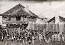
|---|---|
| Description: | Fort Crawford was decommissioned in 1856, having outlived its usefulness as a frontier post. During the Civil War, however, it functioned as a military ho... |

| Date: | 1830 |
|---|---|
| Description: | Fort Winnebago from an original drawing by Jefferson Davis. |

| Date: | 1840 |
|---|---|
| Description: | This map, one of a series made by Thomas Jefferson Cram of the U.S. Topographical Engineers from personal surveys, shows the portage connecting the Wiskons... |
| Date: | 1814 |
|---|---|
| Description: | Fort Shelby built in 1814 and named for the Governor of Kentucky, was surrendered to British forces later in 1814 and renamed Fort McKay. Pictured here is ... |

| Date: | 1814 |
|---|---|
| Description: | Fort Shelby, built by the Americans during the War of 1812. In 1814 the fort surrendered to British forces led by Captain Andrew W. Bulger who renamed it F... |

| Date: | 1840 |
|---|---|
| Description: | Fort Crawford (the second site, with buildings of 1829-?), on the east bank of the Mississippi River, about 2 miles above the mouth of the Wisconsin River. |
| Date: | 1910 |
|---|---|
| Description: | Fort Crawford. Caption reads: "Ruins of hospital, old Fort Crawford, Prairie du Chien, Wis." |
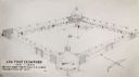
| Date: | 1817 |
|---|---|
| Description: | Sketch of an elevated view of Fort Crawford (1816-1829). |
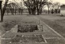
| Date: | 1954 |
|---|---|
| Description: | A view of the site of the original Fort Crawford (1816-1831). |
If you didn't find the material you searched for, our Library Reference Staff can help.
Call our reference desk at 608-264-6535 or email us at: