 Filter: Categories of Wisconsin Historical Images
Filter: Subject of Fortification
Filter: Categories of Wisconsin Historical Images
Filter: Subject of Fortification

| Date: | 1866 |
|---|---|
| Description: | View of earthworks at the battlefield at Resacca. Dirt roads cross the field in the distance, leading to a farm and what appears to be a river. Plate 22... |

| Date: | 1864 |
|---|---|
| Description: | View down to valley of Union soldiers posing on the roof of a log building. A log bridge crosses a stream, and many trees are on the hillsides. Plate 05... |

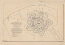
| Date: | 1820 |
|---|---|
| Description: | This map displays the plan for claiming various settlement zones in the Prairie des Chiens area in 1820. It shows Fort Crawford and 87 confirmed and unconf... |
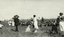
| Date: | 09 05 1921 |
|---|---|
| Description: | Anna Fox, great-grand niece of Ebenezer Brigham, just after removing the flag unveiling the bronze tablet commemorating Fort Blue Mounds. State historical ... |
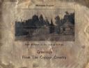
| Date: | 1930 |
|---|---|
| Description: | Holiday card printed on a sheet of copper. It has a scene of log buildings, a stockade fence, and woods in the background. Above is the text "Michigan Copp... |

| Date: | |
|---|---|
| Description: | Valentine's Day card featuring a girl wearing a red uniform and a sword, standing on the roof of a fort. A boy in a tan uniform with a sword, is looking at... |
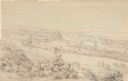
| Date: | 1852 |
|---|---|
| Description: | Landscape view of Fort Snelling, Minnesota Territory from a nearby hill showing the Fort, the Mississippi river, the countryside, farm buildings and tipis.... |

| Date: | |
|---|---|
| Description: | Men work outside dwellings along a shoreline in a reproduction of a painting by W.L. Williams. Copyright by A.S. Burbank, 1891. |

| Date: | 1806 |
|---|---|
| Description: | Prehistoric Indian fortification on Hurricane Creek. |

| Date: | |
|---|---|
| Description: | A map of the prehistoric fort at Circleville with annotations by Daniel Drake. |

| Date: | 1862 |
|---|---|
| Description: | This map lists and depicts the positions of "the batteries on Kentucky shore" and the "batteries on Island No. 10." The 8th Wisconsin Infantry and 15th Wis... |

| Date: | 1942 |
|---|---|
| Description: | These three maps depict the locations of French missions and French forts in Wisconsin, as well as the French place names in the state. |

| Date: | 1941 |
|---|---|
| Description: | This pictorial map of Wisconsin with historical text highlights the history of the state and identifies places of interest, Indian villages, missions, trad... |

| Date: | 1846 |
|---|---|
| Description: | A hand-colored map of Wisconsin shows the counties in the state south and east of the Wisconsin and Fox rivers and the locations of Indian lands to the nor... |

| Date: | 1848 |
|---|---|
| Description: | A map of the Wisconsin and Iowa territories, with the surveyed counties of southern Wisconsin and eastern Iowa identified. The map shows the sectioning of ... |

| Date: | 1848 |
|---|---|
| Description: | Map of Wisconsin and a portion of Minnesota showing the township surveys in progress in portions of the Saint Croix River region and in central Wisconsin a... |

| Date: | 1850 |
|---|---|
| Description: | A hand-colored map showing portions of present-day Iron and Vilas counties north of the Manitowish River as part of the Upper Peninsula of Michigan. The Wi... |

| Date: | 1852 |
|---|---|
| Description: | A hand-colored map showing portions of present-day Iron and Vilas counties north of the Manitowish River as part of the Upper Peninsula of Michigan. The Wi... |
| Date: | 1862 |
|---|---|
| Description: | This detailed plan of Fort Jackson, in Plaquemines Parish, Louisiana, indicates the damage inflicted by the April, 1862, bombardment of the fort by Union f... |

| Date: | 1863 |
|---|---|
| Description: | This map illustrates the position of Fort Hindman at Arkansas Post on the Arkansas River. Depicted are the positions of Confederate defenses as well ships ... |
If you didn't find the material you searched for, our Library Reference Staff can help.
Call our reference desk at 608-264-6535 or email us at: