 Filter: Categories of Wisconsin Historical Images
Filter: Subject of Forests and forestry
Filter: Categories of Wisconsin Historical Images
Filter: Subject of Forests and forestry

| Date: | 1930 |
|---|---|
| Description: | Aerial view of Hoyt Park including the surrounding neighborhoods. Resurrection Cemetery can be seen at the upper right of the image. |

| Date: | 1930 |
|---|---|
| Description: | Aerial view of the University of Wisconsin-Madison Arboretum including a portion of Lake Wingra and surrounding residential neighborhoods. |

| Date: | 1930 |
|---|---|
| Description: | Aerial view of the University of Wisconsin-Madison Arboretum including the surrounding residential neighborhoods. |
| Date: | 1943 |
|---|---|
| Description: | Menominee women working to protect their white pines from blister rust. |

| Date: | 1910 |
|---|---|
| Description: | Aerial view of some of the 26 lakes known collectively as the Chain O' Lakes. Caption reads: "Aeroplane View of Chain O'Lakes, Waupaca, Wis." |

| Date: | 09 1962 |
|---|---|
| Description: | The Mississippi River along Highway 35. |

| Date: | 1910 |
|---|---|
| Description: | Elevated view of North Branch Street. Caption reads: "North Branch Street, Wabeno, Wis." |
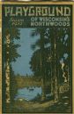
| Date: | 1931 |
|---|---|
| Description: | Cover of a Wisconsin tourism pamphlet for the 1932 season. |
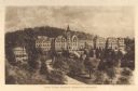
| Date: | 1910 |
|---|---|
| Description: | Elevated view of Saint Clara Academy, formerly known as Saint Clara College. Caption reads: "Saint Clara College — Sinsinawa, Wisconsin". |
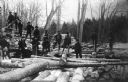
| Date: | 1909 |
|---|---|
| Description: | A group of Native American Indian loggers pose on piles of logs at the Courtes Oreilles Reservation. |

| Date: | 1930 |
|---|---|
| Description: | A view looking west at Rib Mountain across the Wisconsin River from the outskirts of Wausau. |

| Date: | 1939 |
|---|---|
| Description: | A color, pictorial map. Scale: 10 miles to the inch. Shows state parks and forests, proposed state parkways, proposed state monuments and memorials, nation... |
| Date: | 08 15 1955 |
|---|---|
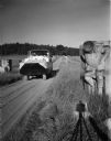
| Description: | Amphibious Duck on land with Board of Trade stone works. The stone gargoyles were salvaged from the Board of Trade building in Chicago by Newman. |
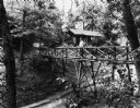
| Date: | 08 1954 |
|---|---|
| Description: | Couple on a wooden bridge over a dirt road at Birchcliff Lodge. |

| Date: | 03 1939 |
|---|---|
| Description: | A man mapping a planted stand of white pines in Devil's Lake State Park. He is wearing snowshoes. |
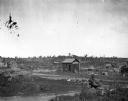
| Date: | |
|---|---|
| Description: | Carter's Siding, a small railroad depot in "cutover" country, showing strong evidence of why formerly forested regions of northern Wisconsin were so named. |

| Date: | 1936 |
|---|---|
| Description: | Loading a large white pine log cut on the Menominee Indian Reservation onto a truck. The log was hauled to the Wisconsin State Fair for a display about the... |
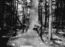
| Date: | 03 1938 |
|---|---|
| Description: | A large white pine being felled on the Menominee Indian Reservation. This photograph was taken to illustrate the tribe's selective logging practices. |
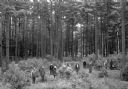
| Date: | 1935 |
|---|---|
| Description: | Slightly elevated view of a ribes eradication crew that was part of the white pine blister rust effort in a Barron County forest. The caption indicates tha... |
If you didn't find the material you searched for, our Library Reference Staff can help.
Call our reference desk at 608-264-6535 or email us at:
