 Filter: Categories of Wisconsin Historical Images
Filter: Subject of Folklore
Filter: Categories of Wisconsin Historical Images
Filter: Subject of Folklore

| Date: | 08 1958 |
|---|---|
| Description: | Group portrait of Thaller's Steak House team, East Midget Central No. 2 champions. Having been unbeaten in 18 games, they lost to Gallagher's in the title ... |

| Date: | 1890 |
|---|---|
| Description: | Grass cutting machinery catalog cover. Features an illustration of a flying putto holding onto a cornucopia spilling flowers into a field. Birds fly in the... |

| Date: | 1941 |
|---|---|
| Description: | This map is ink and watercolor on cardboard and shows Native American legends and villages pictorially. Trails are also shown. |
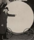
| Date: | |
|---|---|
| Description: | Man in a long coat and hat standing with the large Paul Bunyan drum, which is mounted on wheels. |

| Date: | 08 11 1962 |
|---|---|
| Description: | Youngsters admiring a 10-foot high animated model of legendary lumberjack Paul Bunyan at the Wisconsin State Fair. |

| Date: | 1930 |
|---|---|
| Description: | Original map made with watercolor and inkwash. Includes a legend of buildings, roads, natural features and other details of the lodge. Inset at bottom has ... |

| Date: | 01 1969 |
|---|---|
| Description: | A map of Oneida county, which includes a small drawing of a hodag. |
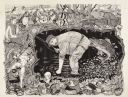
| Date: | 1987 |
|---|---|
| Description: | Imaginative pen-and-ink drawing titled, "Fish Tales (The Truth is Irrelevant, A Lie Well Told Lives Forever)." Sid adds the following words to describe the... |
| Date: | 1985 |
|---|---|
| Description: | Imaginative pen-and-ink drawing that appeared in the Capitol Times May 3, 1985 with Sid's caption: "Charlie Lunker Bass is down at the rustic barber... |
| Date: | 1986 |
|---|---|
| Description: | Imaginative pen-and-ink drawing that appeared in the Capital Times on May 3, 1986 with Sid's caption: "Before fish, all men are created equal. Fish,... |
| Date: | 1974 |
|---|---|
| Description: | Imaginative pen-and-ink drawing of a fisherman in waders, standing in ankle deep water and bending over with one hand in the water. He is looking towards h... |

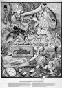
| Date: | |
|---|---|
| Description: | Pen and ink drawing of a fire-breathing dragon cannon on wheels and covered with armor plate. |

| Date: | |
|---|---|
| Description: | A devil with two horns is coming out of a bottle spraying liquid. |

| Date: | 1627 |
|---|---|
| Description: | Map of North and South America showing settlements, rivers, lakes, mountains, islands and regions of the western hemisphere. It includes an inset map of Gr... |

| Date: | 1690 |
|---|---|
| Description: | A mysterious mixture of mythology, ancient geography, and late 17th century knowledge of the American coastline. This map shows North and South America, bu... |

| Date: | 1700 |
|---|---|
| Description: | Map of the western hemisphere showing settelments, coastal features, islands, rivers, lakes, and pictoral representations of forests and mountains. The Gre... |

| Date: | |
|---|---|
| Description: | Sid standing in his kitchen looking at a sculpture of a Viking troll set up on a stool. |

| Date: | 1790 |
|---|---|
| Description: | Map of North America showing cities, states, Native American land, regions, lakes, and rivers. A few notes appear throughout the map, particularly west of ... |

| Date: | 1777 |
|---|---|
| Description: | This important map highlights the frantic desire and search for the north west passage. It shows a few settlements and mountains in Russia, north west Amer... |

| Date: | 1722 |
|---|---|
| Description: | Map of North America including mountains, rivers, lakes, regions, and a few of the most important cities. A highly unusual map with interesting inaccuracie... |
If you didn't find the material you searched for, our Library Reference Staff can help.
Call our reference desk at 608-264-6535 or email us at: