 Filter: Categories of Wisconsin Historical Images
Filter: Subject of Flour mills
Filter: Categories of Wisconsin Historical Images
Filter: Subject of Flour mills

| Date: | |
|---|---|
| Description: | View down cobblestone street toward a girl standing on the steps of the front entrance of a railroad station. Railroad cars on the left of the station are ... |

| Date: | |
|---|---|
| Description: | View of the Fox River. Small boats are docked along the left bank where factory buildings stand. The facade features advertisements for Wrigley's Spearmint... |
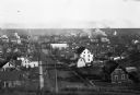
| Date: | |
|---|---|
| Description: | View of a town from an overlooking hill. Beyond dwellings, the Russell-Miller Milling Company is visible; it was built in 1906. |
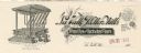
| Date: | |
|---|---|
| Description: | Letterhead of the La Valle Roller Mills, a miller of wheat, rye, and buckwheat flours and cornmeal. Includes illustrations of Plansifter System machinery, ... |
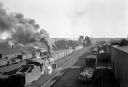
| Date: | |
|---|---|
| Description: | Elevated view of rows of railroad cars can be seen lined up on the tracks outside Minot Flour Mill Company, founded in 1903. |

| Date: | |
|---|---|
| Description: | Two men posed in two wagons, each pulled by teams of two horse. One man is standing and the other is sitting on bags of grain. Behind them a man is posed s... |
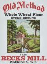
| Date: | 04 09 1935 |
|---|---|
| Description: | Label submitted to the State of Wisconsin for trademark registration. Features an illustration of a mill on a river. "Old Method, Whole Wheat Flour, Stone ... |

| Date: | 03 27 1935 |
|---|---|
| Description: | Label submitted to the State of Wisconsin for trademark registration from the Marshfield Milling Co. "Clover Belt." Includes seven red clovers with green l... |

| Date: | 03 27 1935 |
|---|---|
| Description: | Label submitted to the State of Wisconsin for trademark registration from the Marshfield Milling Co. "Holstein." Holstein cow and calf in black and white c... |

| Date: | 1930 |
|---|---|
| Description: | The rear of the Lemonweir River flour mill and its water reservoir. |
| Date: | 04 29 1900 |
|---|---|
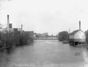
| Description: | View of the Globe Milling Company, built in 1848, and the Lewis Factory on the Rock River. In the distance is a dam, bridge, and barbershop. |

| Date: | 1936 |
|---|---|
| Description: | An International C-35 truck with a 175-inch wheelbase owned by Ogilvie's Flour Mills Company parked in front of the company factory. The factory was locate... |

| Date: | 1871 |
|---|---|
| Description: | This map of Barron County, Wisconsin, shows the township and range grid, towns, sections, cities and villages, post offices, dwellings, schools, roads, swa... |
| Date: | 1936 |
|---|---|
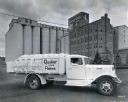
| Description: | An International C-35 truck owned by the Quaker Oats Company parked in front of the Quaker Oats factory in Saskatoon, Saskatchewan, Canada. Sacks of flour ... |

| Date: | 1858 |
|---|---|
| Description: | Map showing roads, mills, and rivers. Date conjectured from presence of Ensign’s Mill and Pitt’s Mill and location of Nekoosa. |

| Date: | 05 1958 |
|---|---|
| Description: | Photocopy of a map created by the City of Milwaukee Master Plan Program City Planning Division in May of 1958 representing 1870 "THE CENTRAL AREA OF THE CI... |

| Date: | |
|---|---|
| Description: | A view of the Wonewoc Mill Company where they manufacture White Swan Flour. Sacks of flour and two men sitting on the loading dock. A woman walking away on... |

| Date: | 1927 |
|---|---|
| Description: | Two men are standing in front of a stone mill house and wooden flume. Another man is just visible crouching inside the doorway of the mill house. The flume... |
| Date: | 1905 |
|---|---|
| Description: | Fred Brendemuehl and Emil Lubich in front of Brendemuehl's feed mill. |

| Date: | 1885 |
|---|---|
| Description: | A detail of a Sanborn map including Catfish Creek and Westport Road by Lake Mendota. |
If you didn't find the material you searched for, our Library Reference Staff can help.
Call our reference desk at 608-264-6535 or email us at: