Filter: Categories of Wisconsin Historical Images
Filter: Subject of Floods
Filter: Categories of Wisconsin Historical Images
Filter: Subject of Floods

| Date: | |
|---|---|
| Description: | Rainwater pooling on the curb and in the driveway of a residence. A garage and well-groomed yard is also visible. A tricycle and coaster wagon are on a wal... |

| Date: | 03 05 1950 |
|---|---|
| Description: | Flooding along University Avenue at Shorewood Boulevard in front of Frenchy's restaurant, 3302 University Avenue. |

| Date: | 03 05 1950 |
|---|---|
| Description: | Flooding along University Avenue at Shorewood Boulevard. Businesses in the photograph include Frenchy's Restaurant, 3302 University Avenue, and the Walter ... |

| Date: | 04 27 1950 |
|---|---|
| Description: | View of damage to the breakwater behind the home of Dr. J.G. Frisch, 1653 Sherman Avenue, caused by high water and waves driven by strong winds. |
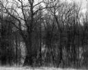
| Date: | 04 18 1965 |
|---|---|
| Description: | View of a wooded area affected by a Wisconsin River flood. |
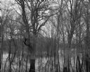
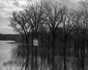
| Date: | 04 18 1965 |
|---|---|
| Description: | View through trees and over water of a small house in a wooded area surrounded by water due to the flooding of the Wisconsin River. |

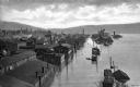
| Date: | 1925 |
|---|---|
| Description: | Elevated view of a small town with a river and bridge in the foreground. High water has washed away the road and river bank at the far end of the bridge. T... |

| Date: | 07 04 1960 |
|---|---|
| Description: | Landscape view of a flooded field at sunrise. |

| Date: | |
|---|---|
| Description: | View of a flooded cornfield with wilted stalks in the foreground. |
| Date: | 05 10 1960 |
|---|---|
| Description: | Grove of trees in a flooded area from a late snow melt. |
| Date: | 04 17 1965 |
|---|---|
| Description: | Flooded woods near the Wisconsin River. A sign for "The Dutch Kitchen" at Hotel Meyers is nailed to one of the trees. |
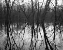
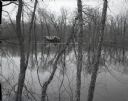
| Date: | 04 18 1965 |
|---|---|
| Description: | View of a grove of trees and their reflections in the flooded Wisconsin River bottomlands. |
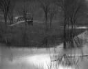
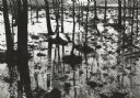
| Date: | 04 18 1965 |
|---|---|
| Description: | A flooded woods near the Wisconsin River. A small bridge and a submerged road are in the background. |
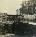
| Date: | |
|---|---|
| Description: | Exterior view of Taliesin showing flood damage. Taliesin is located in the vicinity of Spring Green, Wisconsin. |
| Date: | |
|---|---|
| Description: | Elevated view of Second Street and surrounding area during a flood of the Ohio River. Some buildings are submerged up to their roof lines and the street re... |

| Date: | 09 10 1965 |
|---|---|
| Description: | A New Orleans group hold signs as they rally at Mercy Seat Baptist Church for compensation for lives lost and 25,000 homes ruined during a flood. Reverend ... |

| Date: | |
|---|---|
| Description: | A group of flood victims stand in the rain after (Hurricane) Betsy at Algers Naval Base, where conditions were inadequate for them. |
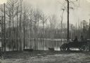
| Date: | 1915 |
|---|---|
| Description: | Three men in an automobile near what may be a flooded area, or possibly an overflowed pond or river. Barren trees stand in the pool's water. |
If you didn't find the material you searched for, our Library Reference Staff can help.
Call our reference desk at 608-264-6535 or email us at: