 Filter: Categories of Wisconsin Historical Images
Filter: Subject of Ferries
Filter: County of Kewaunee
Filter: Categories of Wisconsin Historical Images
Filter: Subject of Ferries
Filter: County of Kewaunee
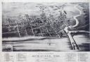
| Date: | 1893 |
|---|---|
| Description: | Bird's-eye map of Kewaunee, with inset of The Kewaunee and Frankfort Car Ferry Line. |
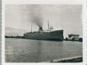
| Date: | 09 15 1960 |
|---|---|
| Description: | View across water towards a carferry named "City of Flint," moored at a dock. There are buildings on the dock on the right. |
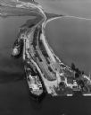
| Date: | 09 17 1948 |
|---|---|
| Description: | Aerial view of two Lake Michigan ferries tied up at harbor slips. The eastern terminus of the Green Bay Route was the Lake Michigan port city of Kewaunee. ... |
If you didn't find the material you searched for, our Library Reference Staff can help.
Call our reference desk at 608-264-6535 or email us at: