 Filter: Categories of Wisconsin Historical Images
Filter: Subject of Express highways
Filter: Categories of Wisconsin Historical Images
Filter: Subject of Express highways
| Date: | 1953 |
|---|---|
| Description: | This map of Beloit shows existing platted streets or highways and proposed street right of way. The map reads: "I hereby certify that this is the official ... |

| Date: | 1951 |
|---|---|
| Description: | This map of Chippewa Falls shows the city of Chippewa River, city limits, roads, highways, fair grounds, and parks. |

| Date: | 1829 |
|---|---|
| Description: | This map of Munnomonee is ink and pencil on tracing cloth. The map shows a plat of the town, local streets, highways, land donations for public use, and pa... |

| Date: | 1974 |
|---|---|
| Description: | This map shows roads, highways, railroads, major arterials, towns, parks, recreational areas, and parts of Fox River and bay of Green Bay. The map includes... |

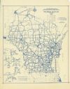
| Date: | 1950 |
|---|---|
| Description: | This map shows portions of highway remaining unchanged, proposed relocations, connecting county trunk roads existing or proposed, existing arterials, and e... |

| Date: | 1857 |
|---|---|
| Description: | This map has relief shown by hachures and pictorially and shows plat of the town, wards, lots, land ownership by name, local roads, highways, railroads, pa... |
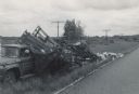
| Date: | 06 07 1966 |
|---|---|
| Description: | View from road of a truck pulled off to the side of the road. The back of the truck is collapsed, containing beehives spilling onto the ground. "E.R. Raley... |

| Date: | 1961 |
|---|---|
| Description: | Evacuation route out of Milwaukee. View from the side of the road looking downhill towards the rear of a Wisconsin State Patrol cruiser parked on the right... |
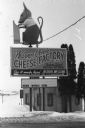
| Date: | 1986 |
|---|---|
| Description: | Warner Creek Cheese billboard, including a 3D sculpture of a mouse with cheese, in front of a small, brick building. Located off the State Highway near Hil... |
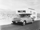
| Date: | 1960 |
|---|---|
| Description: | Man, woman, and a young child holding a pinwheel outside the window, are riding in an International 1966 Travelette pickup with camper attached. They are t... |

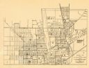
| Date: | 1953 |
|---|---|
| Description: | This map shows local streets, roads, highways, Middleton, Monona, Lake Wingra, Lake Monona, Lake Mendota, and an inset map that shows city parking areas. A... |

| Date: | 1968 |
|---|---|
| Description: | This blue line print shows lot numbers and dimensions, existing or platted streets and highways, streets and highways to be widened, future streets, and vi... |
| Date: | 1937 |
|---|---|
| Description: | This blue line print map shows highways, the scale of traffic volume, and average 24 hour traffic. Also included are inset maps of Green Bay, Oshkosh, Fond... |
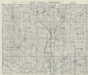
| Date: | 1955 |
|---|---|
| Description: | This cadastral map shows highways, land owners, railroads, and rivers. |

| Date: | 1914 |
|---|---|
| Description: | This map shows main traveled routes. Portions of Lake Michigan, Lake Superior, Illinois, Iowa, Michigan and Minnesota are labeled. Also includes a legend s... |

| Date: | 1916 |
|---|---|
| Description: | This map shows highways, roads, routes, communities, rivers, and lakes. Wide red lines show principle highways. Narrow red lines show secondary roadways or... |

| Date: | 1919 |
|---|---|
| Description: | Narrow red lines show principal secondary highways. Green circles shows points of historical interest. Green triangles show Indian mounds and Indian villag... |

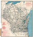
| Date: | 1925 |
|---|---|
| Description: | This map shows the state trunk highway system and county trunk highways. The lower left corner includes a legend of roadway types. Lake Michigan and Lake S... |
| Date: | 1925 |
|---|---|
| Description: | This map shows the state trunk highway system and county trunk highways. The lower left corner includes a legend of roadway types. Lake Michigan and Lake S... |

| Date: | 1926 |
|---|---|
| Description: | This map shows the state trunk highway system and county trunk highways. The lower left corner includes a legend of roadway types. Lake Michigan and Lake S... |
If you didn't find the material you searched for, our Library Reference Staff can help.
Call our reference desk at 608-264-6535 or email us at: