 Filter: Categories of Wisconsin Historical Images
Filter: Subject of Express highways
Filter: Community of Madison
Filter: Categories of Wisconsin Historical Images
Filter: Subject of Express highways
Filter: Community of Madison
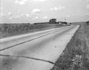
| Date: | 08 29 1933 |
|---|---|
| Description: | US Hwy 12 looking southwest, showing corn fields, McVicar Photo Service case, Sinclair sign and a good view of farm buildings in the background. |

| Date: | 10 16 1962 |
|---|---|
| Description: | The intersection of Interstate Highway I-90 and USH 12/18 east of Madison. This view looks toward the southeast |
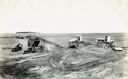
| Date: | 1930 |
|---|---|
| Description: | Construction equipment and dump trucks belonging to the Wagner Erling Company work on the beginnings of Highway 77 in South Dakota. |

| Date: | 1961 |
|---|---|
| Description: | View over beltline of University of Wisconsin-Madison Arboretum along Lake Wingra. Lake Mendota is on upper left, and Lake Monona is on the right, with the... |

| Date: | 09 26 1949 |
|---|---|
| Description: | A car drives down the western portion of the newly opened Madison belt line. The view is looking northwest in the region of Gilbert road (also Whitney Way)... |
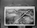
| Date: | 10 11 1950 |
|---|---|
| Description: | Display illustrating the Highway Department's plan for separating highway traffic on Highways 13 and 14 (the Oregon Road) and Highway 12 (the new South Mad... |

| Date: | 1964 |
|---|---|
| Description: | Indexed map. Street names are to the left, map is to the right. Lakes, streets, highways, and points of interest are labelled. |

| Date: | 1953 |
|---|---|
| Description: | This map shows local streets, roads, highways, Middleton, Monona, Lake Wingra, Lake Monona, Lake Mendota, and an inset map that shows city parking areas. A... |

| Date: | 1961 |
|---|---|
| Description: | This street map includes an ancillary map of Dane County highways and a business directory. Lake Mendota, Lake Monona, Monona Bay, Yahara River, and Lake W... |

| Date: | 1968 |
|---|---|
| Description: | This blue line print map shows proposed changes reserving railroad right-of-ways for future highways, land plots, as well as Lake Monona and Lake Mendota. |

| Date: | 10 2013 |
|---|---|
| Description: | View through car windshield of road signs above Interstate 90. The exit for highway 12/18 towards Cambridge is on the right, and the exit for 12/18 towards... |

| Date: | 05 11 1959 |
|---|---|
| Description: | Three people are injured in a two car crash on USH 12 & 18 at the Madison east side city limits at a location referred to as "Crash Curve" by law enforceme... |
If you didn't find the material you searched for, our Library Reference Staff can help.
Call our reference desk at 608-264-6535 or email us at: