 Filter: Categories of Wisconsin Historical Images
Filter: Subject of Exploration
Filter: Categories of Wisconsin Historical Images
Filter: Subject of Exploration

| Date: | 1777 |
|---|---|
| Description: | This important map highlights the frantic desire and search for the north west passage. It shows a few settlements and mountains in Russia, north west Amer... |

| Date: | 1766 |
|---|---|
| Description: | Map representing the northern Pacific Ocean along with north eastern Asia and western North America. The interior of Asia contains very detailed engravings... |

| Date: | 1772 |
|---|---|
| Description: | Map of the north west portion of America and Canada, as well as a small section of eastern Russia. Lakes, rivers, Native American land and the occasional ... |

| Date: | 1770 |
|---|---|
| Description: | Map of North America showing the boundaries between French, Spanish, and English claims after the French and Indian War. Kitchin includes numerous place na... |

| Date: | 1759 |
|---|---|
| Description: | Map of north eastern Canada and parts of New England, showing settlements, cities, portages, Native American land, mountains, lakes, and rivers. The unusua... |
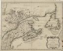
| Date: | 1755 |
|---|---|
| Description: | Bellin's landmark map of eastern Canada and part of northeast America extending from Newfoundland to the borders of Lake Ontario and south to Cape Cod. The... |

| Date: | 1718 |
|---|---|
| Description: | First edition of L'Isle's landmark map of North America. It covers America from the Rio Grande to the Atlantic Ocean, showing boundaries, the colonies, cit... |

| Date: | 1718 |
|---|---|
| Description: | Map of the Southern portion of North America from New Mexico to Florida and south from Lake Erie. It shows borders, cities, settlements, Native American la... |

| Date: | 1720 |
|---|---|
| Description: | Map of North America from from the Rio Grande to the Atlantic Ocean, showing boundaries, the colonies, cities, settlements, mines, forts, Native American l... |

| Date: | 1720 |
|---|---|
| Description: | Detailed, ornate, and comprehensive map of America from the east coast to present day Texas. Numerous features appear throughout the map, including Native ... |

| Date: | 1782 |
|---|---|
| Description: | Map of America covering the Rio Grande to the Atlantic Ocean, showing boundaries, the colonies, cities, settlements, Native American lands and villages, m... |
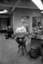
| Date: | 12 04 1957 |
|---|---|
| Description: | Professor Verner Suomi of the University of Wisconsin meteorology department and leader of a university team building one of the U.S. satellites, is shown ... |

| Date: | 01 31 1969 |
|---|---|
| Description: | James Kitchell with a small and large model. Caption reads: "MOON SHIP MODEL — James W. Kitchell, executive producer of NB News' color television coverage ... |

| Date: | |
|---|---|
| Description: | James Kitchell with camera operator in foreground. Men sitting at tables surrounding them are, from left: John Young, Scott Carpenter, Ed White, John Glenn... |

| Date: | |
|---|---|
| Description: | James Kitchell, standing on right, with two men next to him: John Glenn Jr. on the left, and unknown person in the center. |
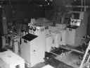
| Date: | 1960 |
|---|---|
| Description: | Caption reads: "Tinius Olsen Automatic Balance Correcting Machine for Engine Crankshafts." |
If you didn't find the material you searched for, our Library Reference Staff can help.
Call our reference desk at 608-264-6535 or email us at: