 Filter: Categories of Wisconsin Historical Images
Filter: Subject of Drawing
Filter: Type of Map or Atlas
Filter: Categories of Wisconsin Historical Images
Filter: Subject of Drawing
Filter: Type of Map or Atlas

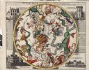
| Date: | 1745 |
|---|---|
| Description: | Zodiac as seen from the Northern Hemisphere. |
| Date: | 1745 |
|---|---|
| Description: | Zodiac as seen from the Southern Hemisphere. |

| Date: | 1850 |
|---|---|
| Description: | Lithograph of a map drawn to indicate a mine on land owned by Mineral Point Mining Co. in the lead region of southwestern Wisconsin. |

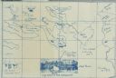
| Date: | 1833 |
|---|---|
| Description: | Drawing on a faint grid with Lake Michigan on the right, and the rivers on the left. Labeled is an Indian Village, J. Veiu, S. Juneau, and P. Juneau. Alo... |

| Date: | |
|---|---|
| Description: | A hand-drawn map of the Guyandotte River. |

| Date: | 1927 |
|---|---|
| Description: | Blueprint-style map of Frost Woods on the shore of Lake Monona. The map indicates the locations of Indian mounds, an Indian camp, and various plants. There... |

| Date: | 1937 |
|---|---|
| Description: | A pictorial, hydrographic map shows sailing courses, historical and contemporary coastal attractions, roads, and the contour depths of Green Lake, Wisconsi... |

| Date: | 1930 |
|---|---|
| Description: | These 40 hand-drawn maps depict the survey townships in Oneida County, Wisconsin, on printed township grids. Lakes, rivers, and waterfront properties are d... |

| Date: | 1712 |
|---|---|
| Description: | This drawing, based on an 1897 survey, appeared in the 1899 Proceedings of the State Historical Society of Wisconsin, accompanying Publius V. Lawson's arti... |

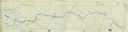
| Date: | 1910 |
|---|---|
| Description: | This map is ink on paper. Shows Bruce’s proposed railway route and Moon’s railroad survey route along the Flambeau River, in parts of Lake and Eisenstein t... |

| Date: | 1978 |
|---|---|
| Description: | Bird’s-eye view map. Shows Madison from the edge of Lake Monona stretching west. Above the map are clouds and in the distance is the edge of the world and ... |

| Date: | 1800 |
|---|---|
| Description: | The map is ink and pencil on paper. Map shows the location of the Ashland Lumber Company as well as a portion of Ashland County. Portions of the map are in... |

| Date: | 1774 |
|---|---|
| Description: | A hand-drawn plat map of Elkcorn (Elkhorn?) Creek. |

| Date: | 1828 |
|---|---|
| Description: | Map of the Louisville and Portland Canal on the Ohio River. The map shows Louisville, Shippingsport, Clarksville, Jeffersonville, Gravel Island, Corn Islan... |

| Date: | 1882 |
|---|---|
| Description: | Plat map of the village of Dunbarton, received by the Lafayette County Register's Office on September 22, 1892. Certification by the surveyor, Albert Pool,... |

| Date: | 1836 |
|---|---|
| Description: | This map shows lot and block numbers, streets, a proposed canal basin, Fort Winnebago, and the Wisconsin and Fox Rivers. Relief is shown by hachures and no... |
| Date: | 1914 |
|---|---|
| Description: | A map, hand-drawn by Carl Greene, of the McFarland Lake (Minnesota) region. The map also includes several clever, humorous drawings referring to some membe... |
| Date: | 1909 |
|---|---|
| Description: | A cyanoprint map of The Gang's journey down the Presque Isle River. There are small drawings around the border depicting the adventures of The Gang and Car... |
If you didn't find the material you searched for, our Library Reference Staff can help.
Call our reference desk at 608-264-6535 or email us at:

