Filter: Categories of Wisconsin Historical Images
Filter: Subject of Church buildings
Filter: Community of La Crosse
Filter: Categories of Wisconsin Historical Images
Filter: Subject of Church buildings
Filter: Community of La Crosse
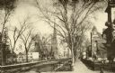
| Date: | 1880 |
|---|---|
| Description: | Stereograph of an elevated view of the Congregational Church. View is from the high school looking down Main Street. |
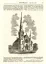
| Date: | 06 26 1869 |
|---|---|
| Description: | An engraving from the Billed-Magazine of the First Congregational Church. |
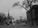
| Date: | 2006 |
|---|---|
| Description: | Scene of 6th Street at dusk. WKBT-TV's satellite dishes visible on right. |
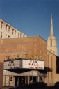
| Date: | |
|---|---|
| Description: | The marquee at the defunct Hollywood Theater reads "for sale." A church steeple is in the background. |

| Date: | 03 01 2005 |
|---|---|
| Description: | A nun praying before the installation of Bishop Jerome Listecki at Cathedral of St. Joseph The Workman. |
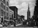
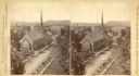
| Date: | 1936 |
|---|---|
| Description: | View down a street filled with automobiles and pedestrians, with buildings lining each side. |
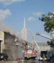
| Date: | 07 30 2011 |
|---|---|
| Description: | Firefighters respond to a fire at the Democratic Party Office at 118 Fifth Avenue. Viewed from Fourth Street intersection. |

| Date: | 1859 |
|---|---|
| Description: | This map show plats including plat names, plat numbers, and some lot owner's names. Relief is shown by hachures. The map includes line drawings of Juneau B... |

| Date: | 1886 |
|---|---|
| Description: | This map has relief shown by hachures and includes a list of plats in order of date of record, laws which vacate plats, plats not shown as upon the county ... |

| Date: | 1888 |
|---|---|
| Description: | This map has relief shown by hachures and features inset maps of a plat of E.D. Clinton and Blackwell’s add’n to the City of La Crosse. Wards (1-10) shaded... |

| Date: | 1857 |
|---|---|
| Description: | This map shows section corners, quarter section corners, foundry, steam saw mill, steam grist mill, planning mill, court house, baptist church, congregatio... |

| Date: | 1927 |
|---|---|
| Description: | This map includes an index and highways marked in red. Attractions on the map include: Four Mile House, Cold Springs, Grand Crossing Station, Coleman Sloug... |
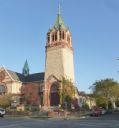
| Date: | 2013 |
|---|---|
| Description: | View across street of the Christ Episcopal Church main tower at the corner of 9th & Main Streets. A man is walking along the sidewalk and automobiles are p... |

| Date: | 1883 |
|---|---|
| Description: | This map shows ward boundaries, names of additions, streets, bridges, mills, schools, religious buildings, businesses, hotels, railroads, factories, brewer... |

| Date: | 1891 |
|---|---|
| Description: | This hand-colored map shows platted additions and subdivisions, ward boundaries, schools, churches, railroads, cemeteries, parks, businesses, factories, an... |
| Date: | 1909 |
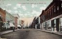
|---|---|
| Description: | Colorized view looking down Main Street. Businesses include a printer, a furniture store, and a telegraph office. A church is on the horizon. Two women are... |
| Date: | |
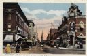
|---|---|
| Description: | View of a central business district. A streetcar and automobiles are in the street. Street lamps are along the curbs, and pedestrians are walking on the st... |
If you didn't find the material you searched for, our Library Reference Staff can help.
Call our reference desk at 608-264-6535 or email us at: