 Filter: Categories of Wisconsin Historical Images
Filter: Subject of Central business districts
Filter: Type of Map or Atlas
Filter: Categories of Wisconsin Historical Images
Filter: Subject of Central business districts
Filter: Type of Map or Atlas

| Date: | 03 1892 |
|---|---|
| Description: | Detail map including West Washington Avenue, West Main Street, West Wilson Street, and North and South Bedford Streets. Includes the Chicago, Milwaukee & S... |

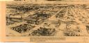
| Date: | 1885 |
|---|---|
| Description: | Bird's-eye map of Oconomowoc. |

| Date: | 1850 |
|---|---|
| Description: | Bird's-eye view of business district of Oshkosh, "drawn after nature" by the artist. |
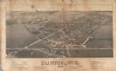
| Date: | 1884 |
|---|---|
| Description: | Like many early settlements of southeastern Wisconsin, Clinton was founded in 1836 by Yankees--immigrants from New England and New York. |

| Date: | 1940 |
|---|---|
| Description: | Shows property ownership, store divisions, and bus stops. "Sept. 12, 1940." Oriented with north to the right. Insets: "Trade area" location map and enlarge... |

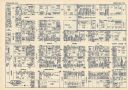
| Date: | 1948 |
|---|---|
| Description: | Map created between 1948 and 1954. Shows businesses and lot owners around the State Capitol. Oriented with north to the upper right. Includes "continued in... |

| Date: | 1955 |
|---|---|
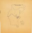
| Description: | Shows city limits, adjoining municipalities, and schools. Indexes, illustrations, ancillary map of Dane County, and ancillary map of Madison business secti... |

| Date: | |
|---|---|
| Description: | Map and advertisement for the Casa del Norte Tea Rooms, with a grid of several blocks in downtown Duluth highlighting the tea rooms as well as other notabl... |
| Date: | 1977 |
|---|---|
| Description: | This map is a bird’s-eye-view of South Milwaukee reproduced in the Oak Creek Pictorial of July 6, 1977. The map was originally published in an unidentified... |
| Date: | 1930 |
|---|---|
| Description: | This map shows local streets, blocks, lots, local businesses by name, and bus stops. On the back of the map is text, illustrations, and aerial views. |
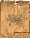
| Date: | 1875 |
|---|---|
| Description: | This map shows plat of the town, land ownership by name, wards, local streets, railroads, and part of Fox River. The map also includes a directory and adve... |

| Date: | 1989 |
|---|---|
| Description: | This pictorial map shows the Sheboygan river, businesses with phone numbers, historical buildings, other places of interest, and includes a brief history o... |
| Date: | 08 1964 |
|---|---|
| Description: | This map shows the city limits, Lake Michigan, the Manitowoc River, Silver Creek, designated sample sites with manuscript annotations, central business dis... |

| Date: | 11 21 1950 |
|---|---|
| Description: | This map shows agricultural, residence, business, and industrial districts as well as lot and block numbers. |
| Date: | 12 1899 |
|---|---|
| Description: | A Sanborn map of Sharon, featuring downtown businesses. |

| Date: | 1908 |
|---|---|
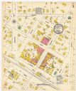
| Description: | A Sanborn map featuring the Capitol Square and surrounding business district. |

| Date: | 10 1884 |
|---|---|
| Description: | A Sanborn map of Watertown, including the City Brewery and the Rock River. |
If you didn't find the material you searched for, our Library Reference Staff can help.
Call our reference desk at 608-264-6535 or email us at: