 Filter: Categories of Wisconsin Historical Images
Filter: Subject of Canals
Filter: Categories of Wisconsin Historical Images
Filter: Subject of Canals

| Date: | 1902 |
|---|---|
| Description: | This map is a chart of Milwaukee Harbor that displays local streets, bridges, roads, railroads, public buildings, businesses, factories, dry docks, parks, ... |

| Date: | 1907 |
|---|---|
| Description: | This map is a chart of Milwaukee Harbor that displays local streets, bridges, roads, railroads, public buildings, businesses, factories, dry docks, parks, ... |

| Date: | 1910 |
|---|---|
| Description: | This ink on paper blue line print base map consists of eight separate pieces and shows city limits, The Milwaukee Electric Railroad & Light Company lines, ... |

| Date: | 12 1886 |
|---|---|
| Description: | This map is ink and pen on tracing cloth and shows land ownership by name, canals, local streets, section lines, and original low water lines in blue. The ... |

| Date: | 1840 |
|---|---|
| Description: | This map shows a line of proposed construction for defending the north side of the canal against inundation from the Wisconsin River and location of Fort W... |
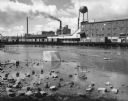
| Date: | 1963 |
|---|---|
| Description: | A diagonal view down the canal of the Menasha Woodenware Company. Along the opposite side of the canal are boxcars on an elevated railroad track over the w... |
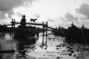
| Date: | 1961 |
|---|---|
| Description: | Silhouetted view across water of a group of people on a small boat near the bridge on the canal at Tan Hung Tay, Vietnam. A dog is crossing the bridge and ... |

| Date: | 1964 |
|---|---|
| Description: | Men and young children in a roofed enclosure outside a dwelling near the village of Binh Hung, South Vietnam. Several of the children are plugging their ea... |
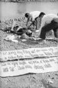
| Date: | 1961 |
|---|---|
| Description: | Body of a Viet Cong sympathizer who had been painting anti-government propaganda banners to hang in a South Vietnamese border village. Some of the banners ... |
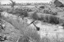
| Date: | 1961 |
|---|---|
| Description: | South Vietnamese soldiers from the Sea Swallow Army wading along a canal on patrol near the village of Binh Hung. Grass buildings are in the background nea... |

| Date: | 1964 |
|---|---|
| Description: | View looking over barbed wire towards a helicopter flying over the village of Binh Hung, a base for the fighting operations for the South Vietnamese. Two c... |

| Date: | |
|---|---|
| Description: | View of a horse hauling dirt on a wagon on tracks. There are five workmen adding dirt to the wagon from a large pile. Identified as part of the Hatfield Ca... |
| Date: | 1900 |
|---|---|
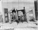
| Description: | Corn binder dismantled for shipping. Some parts are crated. There is a white sheet behind the corn binder serving as a backdrop, and railroad tracks run al... |
| Date: | 1900 |
|---|---|
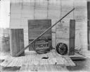
| Description: | Binder dismantled for shipping. There is a white sheet behind the crates serving as a backdrop. In the background on the left are railroad tracks running a... |

| Date: | 1923 |
|---|---|
| Description: | This map includes an explanation that reads: "This chart shows the movement of barley on the Great Lakes, St. Lawrence River, and New York State Barge Cana... |

| Date: | 1923 |
|---|---|
| Description: | This map includes an explanation that reads: "This chart shows the movement of corn on the Great Lakes, St. Lawrence River, and New York State Barge Canal ... |

| Date: | 1923 |
|---|---|
| Description: | This map includes an explanation that reads: "This chart shows the easterly movement of flaxseed on the Great Lakes, St. Lawrence River, and New York State... |

| Date: | 1923 |
|---|---|
| Description: | This map includes an explanation that reads: "This chart shows the movement of grain on the Great Lakes, St. Lawrence River, and New York State Barge Canal... |

| Date: | 1923 |
|---|---|
| Description: | This map includes an explanation that reads: "This chart shows the movement of oats on the Great Lakes, St. Lawrence River, and New York State Barge Canal ... |

| Date: | 1923 |
|---|---|
| Description: | This map includes an explanation that reads: "This chart shows the movement of rye on the Great Lakes, St. Lawrence River, and New York State Barge Canal d... |
If you didn't find the material you searched for, our Library Reference Staff can help.
Call our reference desk at 608-264-6535 or email us at: