Filter: Categories of Wisconsin Historical Images
Filter: Subject of Camping
Filter: County of Vilas
Filter: Categories of Wisconsin Historical Images
Filter: Subject of Camping
Filter: County of Vilas

| Date: | 1962 |
|---|---|
| Description: | This map shows roads, golf courses, ski areas, boat landings, camp sites, waysides, parks, beaches, scenic views, virgin timber tracts, airports, boys and ... |

| Date: | 1955 |
|---|---|
| Description: | This map shows roads, golf courses, airports, fire towers, schools, camp grounds, rivers, streams, lakes, and railroads. The right margin of the map includ... |

| Date: | 1930 |
|---|---|
| Description: | This map shows roads and lakes and includes an inset illustration of Manitowish Waters Fish Hatchery. The back of the map includes a resorts directory, tex... |

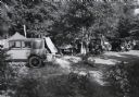
| Date: | 1967 |
|---|---|
| Description: | View down slope towards a green tent pitched on a hill overlooking Star Lake. A man is cooking on a grill near the tent. |
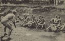
| Date: | 1936 |
|---|---|
| Description: | Text on front reads: "First Lesson in Wrestling, Camp Highlands, on Plum Lake, Sayner, Wisconsin." A teacher begins a class in wrestling with a group of st... |
If you didn't find the material you searched for, our Library Reference Staff can help.
Call our reference desk at 608-264-6535 or email us at: