 Filter: Categories of Wisconsin Historical Images
Filter: Subject of Battlefields
Filter: Community of Manassas
Filter: Categories of Wisconsin Historical Images
Filter: Subject of Battlefields
Filter: Community of Manassas
| Date: | |
|---|---|
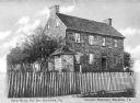
| Description: | A fence surrounds an old stone house and trees at Bull Run Battlefield. Caption reads: "Stone House, Bull Run Battlefield, Va." |

| Date: | 1861 |
|---|---|
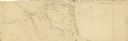
| Description: | This map shows Manassas during the First Battle of Bull Run, in which the 2nd Wisconsin Infantry fought, and the Leesburg area, the site of the Battle of B... |
| Date: | 1862 |
|---|---|
| Description: | This pen and ink drawing of the First Battle of Bull Run, JuIy 21st, 1861, was made by Charles K. Dean, adjutant with the 2nd Wisconsin Infantry. The 2nd W... |

| Date: | 1864 |
|---|---|
| Description: | This map of the area of the First Battle of Bull Run shows military positions and troop movements as well as the names of landowners, vegetation and land u... |
If you didn't find the material you searched for, our Library Reference Staff can help.
Call our reference desk at 608-264-6535 or email us at: