 Filter: Categories of Wisconsin Historical Images
Filter: Subject of Archaeological sites
Filter: Categories of Wisconsin Historical Images
Filter: Subject of Archaeological sites

| Date: | 1929 |
|---|---|
| Description: | The Pond camp at Medfoun, early in the morning. A tent surrounded by camp furniture and supplies is in the center. A truck is parked beside the tent on the... |

| Date: | 1929 |
|---|---|
| Description: | Men excavating a trench in the escargotiere (snail midden) at Medfoun. Brahim is in the trench and Shabane is standing with the shovel. A screen and piles ... |

| Date: | 07 13 1918 |
|---|---|
| Description: | Boxed bones from graves found on University Hill (later Bascom Hill). Two men, seen from the waist down, are standing behind the boxes containing the remai... |

| Date: | 07 13 1918 |
|---|---|
| Description: | View of the excavation of two graves located on University Hill (now Bascom Hill). Main Hall (now Bascom Hall) can be seen in the background. |

| Date: | 01 1969 |
|---|---|
| Description: | A map of Oneida county, which includes a small drawing of a hodag. |
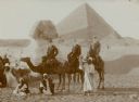
| Date: | 01 1909 |
|---|---|
| Description: | Three men in western dress riding camels pose with their Egyptian guides in front of the Sphinx at the Giza necropolis, with the Cheops pyramid in the back... |
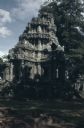
| Date: | 1962 |
|---|---|
| Description: | Outdoor view of a structure that is part of the Angkor Wat Temple, located in Cambodia. |

| Date: | 1930 |
|---|---|
| Description: | A map of the site of a Native American village with a complex of linear raised garden beds and cache pits near Leeman. Also shown are a farmstead, road, an... |

| Date: | 1930 |
|---|---|
| Description: | A composite lantern slide with two early views, ca. 1910, of raised corn hills on the campus of Carroll College (now Carroll University). At top is a view... |

| Date: | 1791 |
|---|---|
| Description: | Small map of an abandoned Native American town and fort at the junction of the Ohio and Muskingum River. It shows the fortifications, an outline of the tow... |
| Date: | 11 15 1925 |
|---|---|
| Description: | View of the tomb of Queen Tin Hinan from the south. Three people are standing on top of the tomb. Mountains and the city of El Oued can be seen in the back... |

| Date: | 11 1925 |
|---|---|
| Description: | Louis Chapuis handing up a Venus statue to Count Byron de Prorok from the Tomb of Tin Hinan in Abelessa, Algeria. |

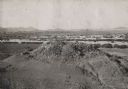
| Date: | 1930 |
|---|---|
| Description: | Poppies blooming in a field in front of a hill, right, identified by the photographer as a shell mound. The dark squares in the side of the mound are proba... |
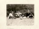
| Date: | 08 01 1929 |
|---|---|
| Description: | Charles Brown and two other men are sitting on the grass at the Shermer Indian Village site. |

| Date: | 1924 |
|---|---|
| Description: | A map of the Madison Township, T7N R9E including Lake Mendota showing the location of Ho Chunk encampments and effigy mounds. |
If you didn't find the material you searched for, our Library Reference Staff can help.
Call our reference desk at 608-264-6535 or email us at:

