 Filter: Categories of Wisconsin Historical Images
Filter: Subject of Aerial photographs
Filter: Categories of Wisconsin Historical Images
Filter: Subject of Aerial photographs

| Date: | 06 07 1954 |
|---|---|
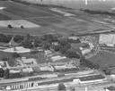
| Description: | Aerial view of the Midvale neighborhood under construction showing the intersection of Midvale and Tokay Boulevards near the southwestern city limits of Ma... |

| Date: | 06 07 1954 |
|---|---|
| Description: | Aerial view looking north from near the city's southwestern limits in 1954. Shows text indicating Midvale Boulevard, Odana Road, Tokay Boulevard, Mineral P... |

| Date: | 1955 |
|---|---|
| Description: | Aerial view of Midvale neighborhood under construction near Madison's southwestern city limits. The view is focused on the area bounded by Tokay Boulevard,... |

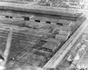
| Date: | 1956 |
|---|---|
| Description: | Aerial view of the Chicago, Milwaukee, and St. Paul Railroad station, roundhouse, and yard at the intersection of West Washington Avenue (across lower left... |

| Date: | 1958 |
|---|---|
| Description: | Aerial view of Craig Avenue and Crestwood Avenue. |
| Date: | 1958 |
|---|---|
| Description: | Aerial photograph showing the J.S. Timlin Lumber Company, 2702 University Avenue, as well as Doctors Park, the Veterans Hospital, and the First Unitarian S... |
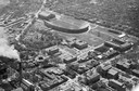
| Date: | |
|---|---|
| Description: | Aerial view of Our Lady Queen of Peace Church. |

| Date: | 1964 |
|---|---|
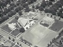
| Description: | Aerial view of the Milwaukee County Zoo grounds nearing its completion. |
| Date: | |
|---|---|
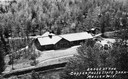
| Description: | Aerial view of a shelter house at Copper Falls State Park. |
| Date: | |
|---|---|
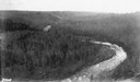
| Description: | Aerial view of the Big Goose Neck in the Bad River at Copper Falls State Park. |

| Date: | 07 10 1949 |
|---|---|
| Description: | Aerial view of Minocqua showing the surrounding lakes. |

| Date: | 1951 |
|---|---|
| Description: | Aerial view of the Nekoosa-Edwards Paper Company nursery. |
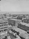
| Date: | |
|---|---|
| Description: | Aerial view northwest from Courthouse of buildings and rooftops. |
| Date: | |
|---|---|
| Description: | Aerial view of buildings with Lake Michigan in the distance. |
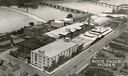
| Date: | 1931 |
|---|---|
| Description: | Aerial view of International Harvester's Rock Falls Works. The factory was owned by the Keystone Manufacturing Company until 1904, when the company was pur... |
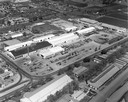
| Date: | |
|---|---|
| Description: | Aerial view of International Harvester's Stockton Works. The factory was originally owned and operated by the Dyrr Manufacturing Company and was in operati... |
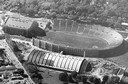
| Date: | 1956 |
|---|---|
| Description: | Aerial view of Camp Randall Stadium and Field House on the University of Wisconsin-Madison campus. |
| Date: | 1954 |
|---|---|
| Description: | Aerial view of Camp Randall Stadium with the University of Wisconsin heating plant in foreground. |

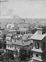
| Date: | 05 09 1908 |
|---|---|
| Description: | Kite aerial panoramic photograph of the central business district. In the distance is Lake Mendota. The fire damaged Wisconsin State Capitol is in the cent... |
| Date: | 1912 |
|---|---|
| Description: | Cicero Field, the airfield operated by the Aero Club of Illinois, as photographed by DeLloyd Thompson from a Wright plane that was piloted by Jesse Brabazo... |
If you didn't find the material you searched for, our Library Reference Staff can help.
Call our reference desk at 608-264-6535 or email us at: