Filter: Categories of Wisconsin Historical Images
Filter: Subject of Aerial photographs
Filter: County of Juneau
Filter: Categories of Wisconsin Historical Images
Filter: Subject of Aerial photographs
Filter: County of Juneau

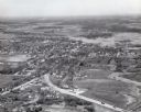
| Date: | 1953 |
|---|---|
| Description: | Aerial view of Wonewoc with hills or bluffs in the foreground on the right. |

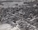
| Date: | 1953 |
|---|---|
| Description: | An aerial view of Wonewoc showing central businesses and a railroad. |

| Date: | 1979 |
|---|---|
| Description: | Aerial view of Interstate I-90/94 at Camp Douglas, looking northwest. |

| Date: | 1957 |
|---|---|
| Description: | Aerial view of town including water tower, city streets, houses, and other buildings. |
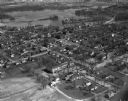
| Date: | 1957 |
|---|---|
| Description: | Aerial view of town including houses, water tower, city streets and buildings. |

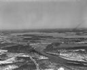
| Date: | 1950 |
|---|---|
| Description: | Aerial view of the Highway 21 bridge and Petenwell Dam on the Wisconsin River. |

| Date: | 03 16 1949 |
|---|---|
| Description: | Aerial view of Mauston, Wisconsin. |
| Date: | 04 16 1949 |
|---|---|
| Description: | Aerial view of Necedah, Wisconsin, and Petenwell Lake behind Petenwell Dam on the Wisconsin River. |
| Date: | 04 16 1949 |
|---|---|
| Description: | Aerial view of Castle Rock Dam on the Wisconsin River near Mauston, Wisconsin. |
| Date: | 04 16 1949 |
|---|---|
| Description: | Aerial view of Petenwell Dam and dike on Wisconsin River twenty miles north of Necedah, Wisconsin showing the early formation of Lake Petenwell. |
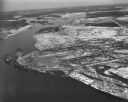
| Date: | 04 27 1949 |
|---|---|
| Description: | Camp Douglas with Volk Field in the background. |
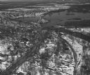
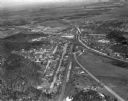
| Date: | 04 27 1949 |
|---|---|
| Description: | Aerial view of New Lisbon. |
If you didn't find the material you searched for, our Library Reference Staff can help.
Call our reference desk at 608-264-6535 or email us at: