Filter: Categories of Wisconsin Historical Images
Filter: FULL_DATE of 1974
Filter: Categories of Wisconsin Historical Images
Filter: FULL_DATE of 1974

| Date: | 1974 |
|---|---|
| Description: | Marine Frank Huff, with upraised fist, being arrested by an MP near the Iwakuni Marine Base in Japan. Huff, a member of the GI movement of the early 1970s... |

| Date: | 1974 |
|---|---|
| Description: | View looking southeast from the State Historical Society of Wisconsin toward the University Club, the Pres House, and dormitories in the far background. |
| Date: | 1974 |
|---|---|
| Description: | Angry letter written to Women for a Peaceful Christmas in opposition to their Christmas shopping boycott, signed "A small business owner." |

| Date: | 1974 |
|---|---|
| Description: | Two men applying systemic fungicide to an American Elm on a residential street through a gravity-feed. |
| Date: | 1974 |
|---|---|
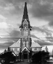
| Description: | "In 1974, Lomira had a tornado that damaged St. John's Church." |
| Date: | 1974 |
|---|---|
| Description: | "The Lomira Legion building is framed in the arch of the Highway 67 overhead." |
| Date: | 1974 |
|---|---|
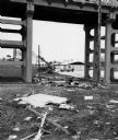
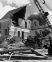
| Description: | "The tornado destroyed the Martin & Marcella Enderle home." |
| Date: | 1974 |
|---|---|
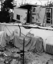
| Description: | "Dismantling St. Theresa Catholic School." |

| Date: | 1974 |
|---|---|
| Description: | "Gordon Neitzel keeps tabs on a village election." |
| Date: | 1974 |
|---|---|
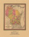
| Description: | A map that was originally published around 1851 in S. Augustus Mitchell's New universal atlas, shows portions of present-day Iron and Vilas counties north ... |

| Date: | 1974 |
|---|---|
| Description: | Campaigning at the Northern Wisconsin Fair, Democratic Congressman David R. Obey (left) of Wisconsin checked out the booth sponsored by the local Republica... |
| Date: | 1974 |
|---|---|
| Description: | This map is a 9 part map detailing various parts of Menominee County, Wisconsin. Page 1 of the map shows federal aid control in the county and was used by ... |
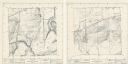
| Date: | 1974 |
|---|---|
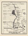
| Description: | These topographical maps illustrate sections 16 and 17 in the Town of Rochester, Racine County, Wisconsin, as of the summer of 1974. |

| Date: | 1974 |
|---|---|
| Description: | This 1968 map identifies resorts in the Lac du Flambeau Indian Reservation region of Wisconsin, covering parts of Iron, Vilas, Oneida, and Price counties. ... |

| Date: | 1974 |
|---|---|
| Description: | This 1974 map is a reproduction of the original survey maps of the Four Lakes region of Dane County, Wisconsin. It shows sections, lakes, rivers, wetlands,... |

| Date: | 1974 |
|---|---|
| Description: | Waist-up seated portrait of De Antonio sitting in front of a door. He is smiling and holding a blurry hand up to the camera, obscuring part of his face. Dr... |

| Date: | 1974 |
|---|---|
| Description: | Waist-up seated portrait of De Antonio, who is smiling and seated in front of a door. Dressed very casually, he wears a plain cotton t-shirt, and a chain a... |
If you didn't find the material you searched for, our Library Reference Staff can help.
Call our reference desk at 608-264-6535 or email us at: