 Filter: Categories of Wisconsin Historical Images
Filter: FULL_DATE of 1973
Filter: Categories of Wisconsin Historical Images
Filter: FULL_DATE of 1973
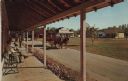
| Date: | 1973 |
|---|---|
| Description: | Color postcard of Main Street from porch on building at Stonefield Village. A horse bus with tourists is in the street. |

| Date: | 1973 |
|---|---|
| Description: | Poster advertising a screening of Emile de Antonio's 1973 documentary film "Painters Painting," about the New York art scene. The screening was at the Hopk... |

| Date: | 1973 |
|---|---|
| Description: | This map is a photocopy of the original plat of Beloit from 1838. The map shows labeled roads, lots, and rivers. |
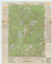
| Date: | 1973 |
|---|---|
| Description: | This standard U.S.G.S. topographic map was annotated by civil engineer and railroad historian James P. Kaysen to show the location of existing and defunct ... |

| Date: | 1973 |
|---|---|
| Description: | This map includes an index of streets and schools and also shows parks, schools and public lands, and industrial sites. Portions of the map are in green an... |

| Date: | 1973 |
|---|---|
| Description: | The Obey family poses for a casual outdoor portrait seated on a rock wall. (Left to right), David, Craig, Douglas and Joan. Craig is holding a basketball. ... |

| Date: | 1973 |
|---|---|
| Description: | Exterior view of St. Martin's Lutheran Church. Dedicated 1886; used continuously until 1973. |

| Date: | 1973 |
|---|---|
| Description: | Alma Schmidt Petersen, left, poses with her sister, Clara Theresa (Tessa) Schmidt Reese, and brother-in-law Dr. Hans Reese on the shrub-bordered brick driv... |

| Date: | 1973 |
|---|---|
| Description: | French film poster for the Swedish film, "Viskningar och rop." Photographic image of four women walking through a park under trees, with a lake in the back... |

| Date: | 1973 |
|---|---|
| Description: | Head and shoulders portrait of Mary Lou Munts. She was elected to the State Assembly in 1972, and was co-sponsor of an equal rights bill that eliminated se... |

| Date: | 1973 |
|---|---|
| Description: | Social action poster advertising Native American Week, January 26-Feburuary 3, 1973. In the center is a photograph of two Native Americans, an adult and a ... |

| Date: | 1973 |
|---|---|
| Description: | Brooks McCormick shaking hands with Richard Lugar, the mayor of Indianapolis. |

| Date: | 1973 |
|---|---|
| Description: | This map shows the uses of land in St. Croix County. Uses are indicated by colored dots. Residential(Yellow), Commercial(Red), Industrial(Grey), Parks and ... |

| Date: | 1973 |
|---|---|
| Description: | This map shows cities, historical markers, interstate highways, U.S. highways, state highways, state parks and state forests. The original caption reads, "... |

| Date: | 1973 |
|---|---|
| Description: | This map is 1 of 7 and includes a location map and township diagram in the margins. The map includes a key of land type: Residential (yellow), Commercial (... |

| Date: | 1973 |
|---|---|
| Description: | This map is 2 of 7 and includes a location map and township diagram in the bottom margin. The map includes a key of land type: Residential (yellow), Commer... |

| Date: | 1973 |
|---|---|
| Description: | This map is 3 of 7 and includes a location map and township diagram in the margins. The map includes a key of land type: Residential (yellow), Commercial (... |

| Date: | 1973 |
|---|---|
| Description: | This map is 4 of 7 and includes a location map and township diagram in the left margin. The map includes a key of land type: Residential (yellow), Commerci... |

| Date: | 1973 |
|---|---|
| Description: | This map is 5 of 7 and includes a location map and township diagram in the left margin. The map includes a key of land type: Residential (yellow), Commerci... |

| Date: | 1973 |
|---|---|
| Description: | This map is 6 of 7 and includes a location map and township diagram in the bottom margin. The map includes a key of land type: Residential (yellow), Commer... |
If you didn't find the material you searched for, our Library Reference Staff can help.
Call our reference desk at 608-264-6535 or email us at: