 Filter: Categories of Wisconsin Historical Images
Filter: FULL_DATE of 1947
Filter: Type of Map or Atlas
Filter: Categories of Wisconsin Historical Images
Filter: FULL_DATE of 1947
Filter: Type of Map or Atlas

| Date: | 1947 |
|---|---|
| Description: | An ink on paper, hand-drawn map of Jefferson County, Wisconsin, that identifies named hills, other points of interest, and the Lake Mills moraine system in... |

| Date: | 1947 |
|---|---|
| Description: | A map of Manitowoc County that shows the location and dates of seven pig fairs in the county; it also lists monthly pig and cattle sales in the surrounding... |

| Date: | 1947 |
|---|---|
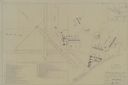
| Description: | Shows lot and block numbers, 28 points of interest in the upper left that correspond to numbers on the map, and landownership with acreages. "Erickson Brot... |

| Date: | 1947 |
|---|---|
| Description: | Lower left hand corner features a legend. "Drawn 1938, revised 1947." Shows water mains, hydrants, corporation limits, city ward divisions, fire proof buil... |
| Date: | 1947 |
|---|---|
| Description: | Map includes a legend identifying four types of runway lights for aircraft, and a building index. The map includes an inset of the site and location plan. ... |
| Date: | 1947 |
|---|---|
| Description: | Map shows land ownership, residential zones, commercial zones, and light industrial zones. Includes inset and location map. Also includes zoning ordinance ... |

| Date: | 1947 |
|---|---|
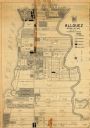
| Description: | This map of Wauwatosa shows 10 zoning class types of land including residential, manufacturing, and business. The map also shows government buildings, some... |

| Date: | 1947 |
|---|---|
| Description: | This map of Ashland is a cadastral map showing some rural landowners and includes index to points of interest. The map shows roads, railroads, parks, cemet... |
| Date: | 1947 |
|---|---|
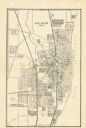
| Description: | This map of Racine has labeled streets, the Root River, Lake Michigan, and includes manuscript annotations of newly annexed areas and African-American neig... |

| Date: | 1947 |
|---|---|
| Description: | This map shows lakes, rivers, railroads, and the soil types of Langlade County. Legends of soil types, conventional signs, and stoniness and slope are incl... |

| Date: | 1947 |
|---|---|
| Description: | This map shows various types of forests, nurseries, state fish hatcheries, major wood-using industries, camp & picnic grounds, fire towers, ranger stations... |

| Date: | 1947 |
|---|---|
| Description: | This map shows territorial roads laid out and opened between 1836 to 1848. Includes a scale in miles. Routes are labeled by numbers and indicated in key on... |

| Date: | 1947 |
|---|---|
| Description: | This map shows the territories of Chippewa, Sioux, Winnebago, and Monomone tribes. It also shows navigation notes for rivers and lakes, Indian villages, hi... |

| Date: | 1947 |
|---|---|
| Description: | Map showing plats, streets, and the public square. The bottom margin of the map includes registration and certifications. |

| Date: | 1947 |
|---|---|
| Description: | This photocopy of a hand-drawn map shows streets, a public square, lots, and extensive registrations and certifications. |
If you didn't find the material you searched for, our Library Reference Staff can help.
Call our reference desk at 608-264-6535 or email us at: