Filter: Categories of Wisconsin Historical Images
Filter: FULL_DATE of 1939
Filter: Categories of Wisconsin Historical Images
Filter: FULL_DATE of 1939

| Date: | 1939 |
|---|---|
| Description: | The intersection of West Main and North Carroll streets with St. Raphael's in the distance. |

| Date: | 1939 |
|---|---|
| Description: | The snowy intersection of South Blair and East Main Streets. |
| Date: | 1939 |
|---|---|
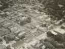
| Description: | Aerial view of church and surrounding buildings. |
| Date: | 1939 |
|---|---|
| Description: | The proposed Mendota Lake Front Development Plan, William Kaeser, architect. |

| Date: | 1939 |
|---|---|
| Description: | A color, pictorial map. Scale: 10 miles to the inch. Shows state parks and forests, proposed state parkways, proposed state monuments and memorials, nation... |
| Date: | 1939 |
|---|---|
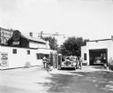
| Description: | A serviceman checks the oil of a car at the Madison Co-op Station. During the 1930s the cooperative movement in Wisconsin expanded its rural base to offer ... |
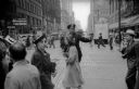
| Date: | 1939 |
|---|---|
| Description: | A Chicago police officer holds up his hand to signal pedestrians that they should not enter the crosswalk. |
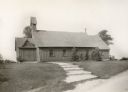
| Date: | 1939 |
|---|---|
| Description: | Holy Innocents Protestant Episcopal Church "at the northeast corner of the intersection of Highway 16 with a road which goes north and south from Delafield... |
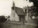
| Date: | 1939 |
|---|---|
| Description: | St. Mary's in the Field, an Episcopal church "located at the northwest corner of the intersection of highways 67 and 18. It is just east of the former Van ... |

| Date: | 1939 |
|---|---|
| Description: | Exterior view of the "Old Spring Hotel" located at 3706 Nakoma Road, built in 1854. Also called "Gorham's Hotel" and "Old Spring Tavern." |

| Date: | 1939 |
|---|---|
| Description: | View down Main Street towards the Park Hotel at the corner of Carroll and Main Streets. Located on the first floor of the hotel is The Park Hotel Barber Sh... |

| Date: | 1939 |
|---|---|
| Description: | Exterior view of the Pierce home, at 424 North Pinckney Street. |

| Date: | 1939 |
|---|---|
| Description: | South Pinckney Street on the Capitol Square. The view includes several retail shops and a women's clothing store. |
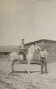
| Date: | 1939 |
|---|---|
| Description: | Gaylord Nelson, later Wisconsin governor, United State senator, and a leading environmentalist of his era, on horseback at a ranch in Rosebud, Montana. |

| Date: | 1939 |
|---|---|
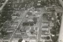
| Description: | Aerial view of commercial section of Monroe, WI. Green County Courthouse is pictured in the middle of the town square. |

| Date: | 1939 |
|---|---|
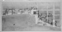
| Description: | Aerial view of International Harvester's Geelong Works in Geelong, Victoria, Australia. |

| Date: | 1939 |
|---|---|
| Description: | Shocks of wheat lined up in a large field. There is a mountain range in the background. |
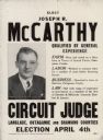
| Date: | 1939 |
|---|---|
| Description: | Campaign poster for Joseph R. McCarthy's campaign for circuit judge. McCarthy was considered an underdog in this race, but he campaigned successfully by dr... |
If you didn't find the material you searched for, our Library Reference Staff can help.
Call our reference desk at 608-264-6535 or email us at: