 Filter: Categories of Wisconsin Historical Images
Filter: FULL_DATE of 1931
Filter: Type of Map or Atlas
Filter: Categories of Wisconsin Historical Images
Filter: FULL_DATE of 1931
Filter: Type of Map or Atlas
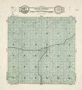
| Date: | 1931 |
|---|---|
| Description: | A map of the township of Verona, Wisconsin. |

| Date: | 1931 |
|---|---|
| Description: | A map of the village of Verona, Wisconsin. |
| Date: | 1931 |
|---|---|
| Description: | This map "sets out the more important points of historic interest designated by the National Society of Colonial Dames in Wisconsin" and includes illustrat... |

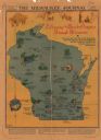
| Date: | 1931 |
|---|---|
| Description: | This U.S. Geological Survey map of Wisconsin shows counties, cities and villages, lighthouses, Indian reservations, military reservations, and bird and gam... |

| Date: | 1931 |
|---|---|
| Description: | This map of south central Wisconsin shows lakes, rivers, cities, villages, highways and roads, railroads, Indian mounds, and points of scenic and historic ... |

| Date: | 1931 |
|---|---|
| Description: | A topographical map from the U.S. Army Corp of Engineers showing the topography and man-made features in the Camp Williams area of the towns of Orange and ... |
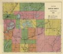
| Date: | 1931 |
|---|---|
| Description: | This 1931 map of Sawyer County, Wisconsin, shows the township and range system, towns, sections, cities and villages, railroads, highways and roads, and la... |
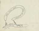
| Date: | 1931 |
|---|---|
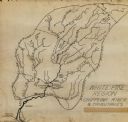
| Description: | Prepared by Robert K. Boyd for his article "Up and down the Chippewa River" which appeared in the March 1931 issue of the Wisconsin Magazine of History, th... |
| Date: | 1931 |
|---|---|
| Description: | This manuscript map shows the Chippewa River watershed, including the Red Cedar or Menomonie River, Flambeau or Manitowish River, Jump River, Eau Claire Ri... |

| Date: | 1931 |
|---|---|
| Description: | This map is an advertisement for Milwaukee street cars and motor buses and reads: "Ride the street car or motor bus. Economical, safe, dependable." Include... |
| Date: | 1931 |
|---|---|
| Description: | Top of the map reads: "SPECIAL MILITARY MAP 2626:2757:/27:2080:" and "Advance sheet, subject to correction." Bottom right of the map reads: "South Range gu... |

| Date: | 1931 |
|---|---|
| Description: | Relief shown by contours and spot heights. Maps shows United States, state, county and local highways and roads, schools, North Bend, creeks, lakes, rivers... |

| Date: | 1931 |
|---|---|
| Description: | Map shows street map with wards numbered, the Fox River, railroads, playgrounds, cemeteries, and schools. The map also includes a manuscript annotation ind... |

| Date: | 1931 |
|---|---|
| Description: | This map of Ashland shows roads, railroads, and local businesses. The map reads: "Showing streets and roads open to the public Oct. 1, 1931." Included on t... |

| Date: | 1931 |
|---|---|
| Description: | This map shows streets and highways, street car and bus lines, railroads, depots, schools, wards, and points of interest. The map is oriented with the nort... |

| Date: | 1931 |
|---|---|
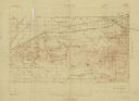
| Description: | This map shows the state trunk highway system and county trunk highways. This map show surface type on state and county trunk highways and the locations of... |

| Date: | 1931 |
|---|---|
| Description: | Road map of Wisconsin featuring the major freeways, highways, and cities. The front contains an index and a guide to the population of the various cities.... |

| Date: | 1931 |
|---|---|
| Description: | This map shows heavy industrial districts (yellow), commercial and light manufacturing districts (red), and residential districts (white) as well as a plat... |

| Date: | 1931 |
|---|---|
| Description: | This photocopy map shows lot and block numbers, some landownership and acreages, water flowage, and marshes. The map also shows Lake Menomin and Wilson Cr... |
| Date: | 1931 |
|---|---|
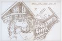
| Description: | Fold-out map of the zoo inside a publication titled: "The Master Plan For Henry Vilas Park Zoo." Includes Lake Wingra, the lagoon, and the playground. |
If you didn't find the material you searched for, our Library Reference Staff can help.
Call our reference desk at 608-264-6535 or email us at: