 Filter: Categories of Wisconsin Historical Images
Filter: FULL_DATE of 1929-07
Filter: Year of 1900-1999
Filter: Categories of Wisconsin Historical Images
Filter: FULL_DATE of 1929-07
Filter: Year of 1900-1999
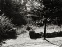
| Date: | 07 1929 |
|---|---|
| Description: | View of the front path leading to the cottage. |
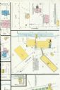
| Date: | 07 1929 |
|---|---|
| Description: | Sheet 10 of a Sanborn map of a portion of Mineral Point. |
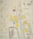
| Date: | 07 1929 |
|---|---|
| Description: | Sheet 9 of a Sanborn map of a portion of Mineral Point. |
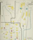
| Date: | 07 1929 |
|---|---|
| Description: | A detail of a Sanborn map of Grafton including the New York Recording Laboratory. |

| Date: | 07 1929 |
|---|---|
| Description: | View of a farm taken from a field. Barn, farmhouse, and a windmill are visible behind trees, perhaps an orchard. |

| Date: | 07 1929 |
|---|---|
| Description: | View uphill towards the entrance to the McSherry Cave. A woman is standing at the entrance. Trees and shrubs are growing on top of the cave. |
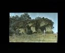
| Date: | 07 1929 |
|---|---|
| Description: | View uphill towards the entrance to the McSherry Cave. A woman is standing at the entrance. Trees and shrubs are growing on top of the cave. |
If you didn't find the material you searched for, our Library Reference Staff can help.
Call our reference desk at 608-264-6535 or email us at: