 Filter: Categories of Wisconsin Historical Images
Filter: FULL_DATE of 1927
Filter: County of Milwaukee
Filter: Categories of Wisconsin Historical Images
Filter: FULL_DATE of 1927
Filter: County of Milwaukee

| Date: | 1927 |
|---|---|
| Description: | Color map, hand-drawn with comic figures engaged in various activities throughout map. Bordered by the river on the left and Lake Michigan on the right, in... |
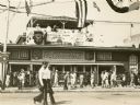
| Date: | 1927 |
|---|---|
| Description: | Crowds walking past the Horticulture Building at the Wiconsin State Fair. In a pavilion above the building the Aluminum Goose Manufacturing Co. Band of Ma... |

| Date: | 1927 |
|---|---|
| Description: | Portrait of the Seiden family (wife and in-laws of Salvator Moshe). Front row, from left: Thelma Seiden Moshe (wife), Max (father-in-law), Bessie (mother-... |

| Date: | 1927 |
|---|---|
| Description: | Newspaperman Alvin Steinkopf leaning on a large radio in his Milwaukee apartment. Steinkopf is wearing a bow tie and holding a cigar in his hand. |

| Date: | 1927 |
|---|---|
| Description: | Street railway and motor bus map with a legend of "Street Car Line," "Auxiliary Bus Lines," and "Motor Bus Lines." The routes are numbered. The map reads: ... |

| Date: | 1927 |
|---|---|
| Description: | This map shows street car lines, bus routes, railroads, proposed city boundary lines, wards, public schools, blocks & house numbers, Lake Michigan, one mil... |

| Date: | 1927 |
|---|---|
| Description: | This map shows highways, roads, a proposed annexation, street car lines, bus routes, local motor bus lines, a new high speed interurban, railroads, a propo... |
If you didn't find the material you searched for, our Library Reference Staff can help.
Call our reference desk at 608-264-6535 or email us at: