 Filter: Categories of Wisconsin Historical Images
Filter: FULL_DATE of 1927
Filter: Type of Map or Atlas
Filter: Categories of Wisconsin Historical Images
Filter: FULL_DATE of 1927
Filter: Type of Map or Atlas

| Date: | 1927 |
|---|---|
| Description: | Color map, hand-drawn with comic figures engaged in various activities throughout map. Bordered by the river on the left and Lake Michigan on the right, in... |

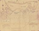
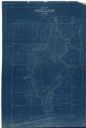
| Date: | 1927 |
|---|---|
| Description: | Blueprint-style map of Frost Woods on the shore of Lake Monona. The map indicates the locations of Indian mounds, an Indian camp, and various plants. There... |
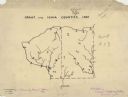
| Date: | 1927 |
|---|---|
| Description: | A hand-drawn map outlining the counties of Grant and Iowa counties as they would have appeared in 1837. |

| Date: | 1927 |
|---|---|
| Description: | This 1927 map of Sawyer County, Wisconsin, shows the township and range system, sections, cities and villages, roads, railroads, and lakes and streams. |
| Date: | 1927 |
|---|---|
| Description: | Shows section corners, landownership and acreages, roads, railroad, Weston village, and buildings of W.J. Starr Estate. Relief shown by hachures. "Map comp... |
| Date: | 1927 |
|---|---|
| Description: | Shows landowner's lots, roads, railroads, and Fox River. Also includes certificate of survey text. Includes significant manuscript annotations depicting th... |

| Date: | 1927 |
|---|---|
| Description: | Street railway and motor bus map with a legend of "Street Car Line," "Auxiliary Bus Lines," and "Motor Bus Lines." The routes are numbered. The map reads: ... |

| Date: | 1927 |
|---|---|
| Description: | Shows campus buildings, points of interest in surrounding area, and railroads. Advertisements on verso. |

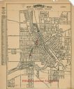
| Date: | 1927 |
|---|---|
| Description: | Map reads: "Now You Can Visualize Madison". Includes indexes, with points marked 1-98 and a key. Text and illustrations on verso include hotels and seasona... |

| Date: | 1927 |
|---|---|
| Description: | This map includes an index and highways marked in red. Attractions on the map include: Four Mile House, Cold Springs, Grand Crossing Station, Coleman Sloug... |
| Date: | 1927 |
|---|---|
| Description: | This map shows a plat of city, a numbering system, local streets, railroads, and part of the Rock River. The map is indexed by street name and reads: "Copy... |

| Date: | 1927 |
|---|---|
| Description: | This map shows street car lines, bus routes, railroads, proposed city boundary lines, wards, public schools, blocks & house numbers, Lake Michigan, one mil... |

| Date: | 1927 |
|---|---|
| Description: | This map shows highways, roads, a proposed annexation, street car lines, bus routes, local motor bus lines, a new high speed interurban, railroads, a propo... |

| Date: | 1927 |
|---|---|
| Description: | This map shows the state trunk highway system and county trunk highways. The lower left corner includes a legend of roadway types. Lake Michigan and Lake S... |
| Date: | 1927 |
|---|---|
| Description: | This blueprint map shows landownership around the lake. Water depths are shown by soundings; relief is shown by hachures. The map was originally created in... |

| Date: | 1927 |
|---|---|
| Description: | This Blue line print map shows trade area boundaries, lakes, farm homes, railways, high schools, public highways, and townships. A symbol key is included i... |

| Date: | 1927 |
|---|---|
| Description: | This map shows roads, highways, cities, county boundaries, rivers, lakes and trails. The route from Chicago to Duluth (including Wisconsin Highways 13 and ... |

| Date: | 1927 |
|---|---|
| Description: | These maps are compiled from existing maps created by the Joint Engineering Department, the Wisconsin Railroad, and the Tax Commissions. The maps include n... |

| Date: | 1927 |
|---|---|
| Description: | This map details automobile routes throughout the state as well as parts of Iowa, Minnesota, Michigan and Illinois. Cities, the Mississippi River, Lake Mic... |
If you didn't find the material you searched for, our Library Reference Staff can help.
Call our reference desk at 608-264-6535 or email us at:
