 Filter: Categories of Wisconsin Historical Images
Filter: FULL_DATE of 1920
Filter: Type of Map or Atlas
Filter: Categories of Wisconsin Historical Images
Filter: FULL_DATE of 1920
Filter: Type of Map or Atlas

| Date: | 1920 |
|---|---|
| Description: | A map of Madison and the vicinity. Red lines show the street railway. |

| Date: | 1920 |
|---|---|
| Description: | Map of the Nakoma neighborhood including the proposed golf grounds. |

| Date: | 1920 |
|---|---|
| Description: | Detail of a map of Dane county showing only Verona. |

| Date: | 1920 |
|---|---|
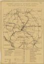
| Description: | Shows 10 land and water trails along rivers and other bodies of water in northern Wisconsin and the Upper Peninsula of Michigan; each trail numbered and de... |
| Date: | 1920 |
|---|---|
| Description: | This map produced just after Word War I shows the proposed location for a veterans' hospital in the Eau Claire-Chippewa Falls region. Highways, rail lines ... |

| Date: | 1920 |
|---|---|
| Description: | A two-sided map of the state of Wisconsin. The front includes towns and major cities as well as state and county trunk highways. The back includes a smalle... |

| Date: | 1920 |
|---|---|
| Description: | This map identifies the areas of the state that had been geologically surveyed or topographically surveyed, or both, as well as portions of the state still... |

| Date: | 1920 |
|---|---|
| Description: | This early road map shows the system of roads in Wisconsin, northern Illinois, northeastern Iowa, southeastern Minnesota, and the western portion of Michig... |

| Date: | 1920 |
|---|---|
| Description: | An ink on tracing paper, hand-drawn map that shows lead mines, the boundary of the lead bearing strata, and the military road in Lafayette, Grant, Iowa, an... |

| Date: | 1920 |
|---|---|
| Description: | A map of the Nelson-Dewey State Park at the confluence of the Mississippi and Wisconsin rivers, showing the topographical features of the area, as well as ... |

| Date: | 1920 |
|---|---|
| Description: | This 1920 map actually depicts present-day Wyalusing State Park at the confluence of the Mississippi and Wisconsin rivers in the Town of Wyalusing, Grant C... |
| Date: | 1920 |
|---|---|
| Description: | This map shows the township and range system, sections, cities and villages, railroads, roads, and streams and lakes in Oconto County, Wisconsin. Color co... |

| Date: | 1920 |
|---|---|
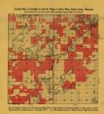
| Description: | This early 1920s map shows state-owned land in townships 38 and 39, range 7 east, the towns of Lake Tomahawk and Woodruff, in Oneida County, Wisconsin, tha... |

| Date: | 1920 |
|---|---|
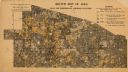
| Description: | This map of Sawyer County, Wisconsin, from the early 20th century shows the township and range system, towns, sections, cities and villages, railroads, hig... |
| Date: | 1920 |
|---|---|
| Description: | This early-20th century map of the towns of Round Lake and Spider Lake, Sawyer County, Wisconsin, shows sections, roads, lake and streams, and land owned a... |

| Date: | 1920 |
|---|---|
| Description: | This map shows the township and range system, sections, schools, churches, cemeteries, town halls, roads, railroads, and lakes and streams in Shawano Count... |
| Date: | 1920 |
|---|---|
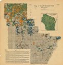
| Description: | This early 20th century map shows the soil types in Vilas County, Wisconsin, and adjoining areas in Oneida, Forest, Iron, and Price counties. Also depicted... |

| Date: | 1920 |
|---|---|
| Description: | This manuscript map of southern Bayfield County, Wisconsin, covers the towns of Cable and Drummond and portions of Grandview and Namekagon. Shown are the t... |

| Date: | 1920 |
|---|---|
| Description: | This map of Devil's Lake State Park in Sauk County, Wisconsin, shows the park limits, railroads, roads, creeks, trails, and points of interest in the area.... |
If you didn't find the material you searched for, our Library Reference Staff can help.
Call our reference desk at 608-264-6535 or email us at:
