 Filter: Categories of Wisconsin Historical Images
Filter: FULL_DATE of 1913
Filter: Type of Map or Atlas
Filter: Categories of Wisconsin Historical Images
Filter: FULL_DATE of 1913
Filter: Type of Map or Atlas

| Date: | 1913 |
|---|---|
| Description: | Bird's-eye map of Superior. "The New Steel Center." |

| Date: | 1913 |
|---|---|
| Description: | Shows lands in green owned and for sale by Homeseekers Land Company, H.J. McKusick, Secretary. Map, part colored. No scale. Photographs on reverse of origi... |

| Date: | 1913 |
|---|---|
| Description: | Wisconsin map showing fifteen hundred miles of national highways proposed by the National Highways Association. Scale: 1:2,500,000. These highways will dir... |

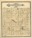
| Date: | 1913 |
|---|---|
| Description: | A wall atlas of Sauk County, Wisconsin, displaying its 22 towns. On the left side are advertisements for local businesses. |

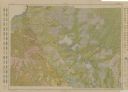
| Date: | 1913 |
|---|---|
| Description: | A hand-colored map of Wisconsin and portions of eastern Iowa and Minnesota, northern Illinois, and the western part of Michigan’s Upper Peninsula, showing ... |

| Date: | 1913 |
|---|---|
| Description: | This 1913 map of Pepin County, Wisconsin, shows the township and range grid, towns, villages, rural routes, railroads, roads, schools, churches, cemeteries... |

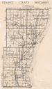
| Date: | 1913 |
|---|---|
| Description: | This early 20th century map of Saint Croix County, Wisconsin, shows the township and range grid, sections, towns, villages, roads, railroads, and lakes and... |

| Date: | 1913 |
|---|---|
| Description: | Map from the U.S. Dept. of Agriculture's Soil Survey shows the soil types in Buffalo County, Wisconsin. The township and range grid, towns, sections, citie... |
| Date: | 1913 |
|---|---|
| Description: | Shows soil types by colors and symbols. Relief shown by contours. Soils surveyed by W.J. Geib, Arthur E. Taylor and Guy Conrey. "Base map in part from U.S.... |

| Date: | 1913 |
|---|---|
| Description: | Ink and watercolor on tracing cloth. Shows parts of Green Lake, Princeton, and Brooklyn townships, Indian mound groups, Green Lake, and other significant b... |

| Date: | 1913 |
|---|---|
| Description: | This map shows city wards and government buildings. The map is oriented with north to upper right. |
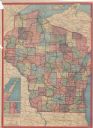
| Date: | 1913 |
|---|---|
| Description: | This map shows automobile roads, cities, county boundaries, rivers, lakes, railroads, electric lines, and congressional districts. Included are portions of... |
| Date: | 1913 |
|---|---|
| Description: | This map shows landownership, rural mail routes, rural buildings, railroads, U.S. national highways, state trunk highways, county trunk highways, township... |

| Date: | 1913 |
|---|---|
| Description: | This photocopy map shows plots with owners' names, land use both commercial and agricultural, and lot outlines on University land. Lake Mendota is labeled ... |

| Date: | 1913 |
|---|---|
| Description: | This map details automobile routes throughout the state and parts of Illinois, Minnesota, Michigan, and Iowa. Cities, counties, Lake Michigan, Lake Superio... |

| Date: | 1913 |
|---|---|
| Description: | This map displays automobile routes across Wisconsin as well as Minnesota, Iowa, Michigan and Illinois. Cities, counties, Lake Michigan, Lake Superior, Gre... |
| Date: | 1913 |
|---|---|
| Description: | A plat map of the township of Norwood in Langlade County. |
If you didn't find the material you searched for, our Library Reference Staff can help.
Call our reference desk at 608-264-6535 or email us at:
