 Filter: Categories of Wisconsin Historical Images
Filter: FULL_DATE of 1904
Filter: Categories of Wisconsin Historical Images
Filter: FULL_DATE of 1904

| Date: | 1904 |
|---|---|
| Description: | Lumberjacks posing together in a bunkhouse at Ole Emerson's lumber camp. There are lanterns hanging from the ceiling. Two of the men are holding fiddles (v... |
| Date: | 1904 |
|---|---|
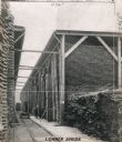
| Description: | Men load pieces of lumber from rolling carts onto piles in open-air sheds at Weber Works in Auburn Park. |

| Date: | 1904 |
|---|---|
| Description: | School #4, Second Grade class, Watertown, Wisconsin. Top Row: Esther Jaeck, unknown, Celest McGobrick, Frank Bomb, Edna Stevy, Ruth Archie, George Dame, Es... |

| Date: | 1904 |
|---|---|
| Description: | A map that shows the location of the lakes and resorts in northeastern Wisconsin that were reachable by the Chicago and North Western Railway. Shown in the... |

| Date: | 1904 |
|---|---|
| Description: | A business map of Wisconsin also including the western portion of Michigan's Upper Peninsula, eastern Iowa and Minnesota, and northern Illinois, showing, r... |

| Date: | 1904 |
|---|---|
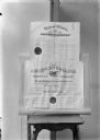
| Description: | Certificate submitted to the state of Wisconsin for trademark registration. "Hotel and Restaurant Employes International Alliance and Bartenders Internatio... |
| Date: | 1904 |
|---|---|
| Description: | The top document is a physician's certificate dated 1904, issued to Herman A. Feiker, brother of photographer, by the State of Illinois. The bottom documen... |

| Date: | 1904 |
|---|---|
| Description: | Aldo Leopold standing in a boat with a group of young people. He is wearing pants, a shirt and a bow tie. Buildings can be seen on the shoreline in the bac... |

| Date: | 1904 |
|---|---|
| Description: | A young Aldo Leopold sitting on a horse with several friends. Handwritten next to the snapshot: "a heavy load." A woman in a dress is holding the horse's l... |

| Date: | 1904 |
|---|---|
| Description: | A young Aldo Leopold is posing smiling, wearing a jacket and bow tie while sitting on a pier. He is vacationing in the Cheneaux Islands. A shoreline with b... |

| Date: | 1904 |
|---|---|
| Description: | A brochure for the lake region of north-eastern Illinois and south-eastern Wisconsin providing information on summer activities and places to stay in the a... |

| Date: | 1904 |
|---|---|
| Description: | Panoramic view of Governor Nelson Dewey's estate. The left image is of an old stone barn with a shed in the rear. The center image is another barn. The rig... |

| Date: | 1904 |
|---|---|
| Description: | View across field of farm on the estate, showing a sheep or horse shed on the left and a cow or horse barn on the right. In the background is a bluff. |
| Date: | 1904 |
|---|---|
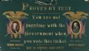
| Description: | A Republican campaign placard that could be hung by a red, white and blue ribbon threaded through eyelets at the top. Portraits of Theodore Roosevelt (cand... |

| Date: | 1904 |
|---|---|
| Description: | This 1904 map of Dane County, Wisconsin, shows postal routes, post office locations, towns, sections, cities and villages, roads, railroads, collection box... |

| Date: | 1904 |
|---|---|
| Description: | Map shows townships and sections, landownership and acreages, roads and railroads, and selected buildings. "1904" inscribed on map in pen. Includes busines... |
| Date: | 1904 |
|---|---|
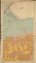
| Description: | This 1904 map from the U.S. Dept. of Agriculture's Bureau of Soils shows the soil types in north-central Douglas County, Wisconsin, and Duluth, Minnesota. ... |

| Date: | 1904 |
|---|---|
| Description: | This map shows lakes, railroads, and rivers. Also includes an explanation of railroad lines and mileage and a table showing miles from cities to Milwaukee.... |

| Date: | 1904 |
|---|---|
| Description: | This map shows numbered wards and plots, labelled streets, and parks in green. |

| Date: | 1904 |
|---|---|
| Description: | Map shows townships and sections, landownership and acreages, roads, railroads, post offices, and farms. On the top, bottom, and sides of map are advertise... |
If you didn't find the material you searched for, our Library Reference Staff can help.
Call our reference desk at 608-264-6535 or email us at: