 Filter: Categories of Wisconsin Historical Images
Filter: FULL_DATE of 1903
Filter: Categories of Wisconsin Historical Images
Filter: FULL_DATE of 1903

| Date: | 1903 |
|---|---|
| Description: | A map of northern Wisconsin and Michigan showing the names and locations hunting and fishing resorts in the area, as well as location of Chicago and North ... |

| Date: | 1903 |
|---|---|
| Description: | A map that shows the location of each county, city and village in Wisconsin; in addition that maps also identifies railroads their distances between cities... |
| Date: | 1903 |
|---|---|
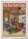
| Description: | Color lithograph poster. "The Factory Girl" in red banner across top. “A Great Labor Play” under title top right. Scene depicting a well-dressed woman whee... |
| Date: | 1903 |
|---|---|
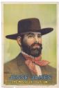
| Description: | Color lithograph poster for "Jesse James / The Missouri Outlaw" consisting of just the bust of the famous outlaw in full beard, with a red and white dotted... |

| Date: | 1903 |
|---|---|
| Description: | Label submitted to the state of Wisconsin for trademark registration. "International Union of the United Brewery Workmen of America, Union Made Beer, Ale a... |

| Date: | 1903 |
|---|---|
| Description: | Interior of a bar in Northern Wisconsin. Two bar patrons are pictured standing in front of the bar, with a bartender posing behind them. The back of the ca... |

| Date: | 1903 |
|---|---|
| Description: | Quarter-length oval studio portrait of Henry Cullen Adams. |

| Date: | 1903 |
|---|---|
| Description: | Composite photograph of one man and two women standing on top of two horses pulling a buggy. The three figures are glued onto the photograph containing the... |

| Date: | 1903 |
|---|---|
| Description: | A cutout of a girl placed in the Diamond Grotto in Witches' Gulch. There is graffiti on the rocks in the background. Text at right: "Wanderings Among the W... |

| Date: | 1903 |
|---|---|
| Description: | Two men canoeing at Steamboat Rock. Text at right: "Wanderings Among the Wonders and Beauties of Wisconsin Scenery." |
| Date: | 1903 |
|---|---|
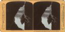
| Description: | A silhouetted man on a boat in a cave. Text at right: "Wanderings Among the Wonders and Beauties of Wisconsin Scenery." |

| Date: | 1903 |
|---|---|
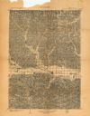
| Description: | This 1903 map of Outagamie County, Wisconsin, shows the township and range grid, towns, sections, cities and villages, landownership and acreages, rural ma... |

| Date: | 1903 |
|---|---|
| Description: | This map of Richland County, Wisconsin, shows land ownership and acreages, the township and range grid, sections, cities, towns and post offices, roads, ra... |
| Date: | 1903 |
|---|---|
| Description: | This topographical map from the U.S. Geological Survey shows parts of Richland, Sauk, Grant, and Iowa counties, Wisconsin, as of 1903. |
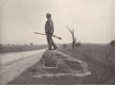
| Date: | 1903 |
|---|---|
| Description: | Statue of John L. Burns, the elderly citizen-hero of the Battle of Gettysburg, who fought with the 7th Wisconsin on July 1, 1863 and was wounded. A veteran... |

| Date: | 1903 |
|---|---|
| Description: | Map of Brown County, Wisconsin, shows the township and range grid, towns, sections, cities, villages and post offices, land owners and acreages, railroads,... |

| Date: | 1903 |
|---|---|
| Description: | Shows lot numbers and dimensions. "Issued May 31, 1903" -- Inscribed in ink. Oriented with north to the upper right. Includes text. Labelled streets are "R... |

| Date: | 1903 |
|---|---|
| Description: | This map is ink on printed paper reading: "standard profile plate." "Surveyed Oct. 15, platted Dec. 15, 1903 ; surveyed May 9, platted Dec. 9." |

| Date: | 1903 |
|---|---|
| Description: | Map shows railroads, roads, street car lines, schools, churches, cemeteries, town halls, and railroad stations. Includes inset lists of: Population of Milw... |
If you didn't find the material you searched for, our Library Reference Staff can help.
Call our reference desk at 608-264-6535 or email us at:
