 Filter: Categories of Wisconsin Historical Images
Filter: FULL_DATE of 1896
Filter: Subject of cities and towns
Filter: Categories of Wisconsin Historical Images
Filter: FULL_DATE of 1896
Filter: Subject of cities and towns
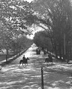
| Date: | 1896 |
|---|---|
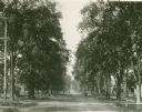
| Description: | Tree-lined State Street from Bascom Hill on the University of Wisconsin-Madison campus. Traffic on State Street includes two well-dressed gentlemen on hors... |
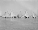
| Date: | 1896 |
|---|---|
| Description: | A gathering of iceboats and their captains on Lake Mendota. |
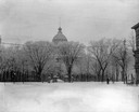
| Date: | 1896 |
|---|---|
| Description: | Winter scene of the third Wisconsin State Capitol looking west from King Street. By the turn of the century, the trees in the Capitol had grown tall and on... |

| Date: | 1896 |
|---|---|
| Description: | Bird's-eye map of Darlington. Area bordered by Washington and North Streets, upper left hand corner, the fairgrounds, upper right corner, River Street, bot... |

| Date: | 1896 |
|---|---|
| Description: | Bird's-eye map of Fond du Lac, looking north west, with two insets of the P.H. Stamm residence, and the Proposed Lakeside Park. thirty-five locations ident... |

| Date: | 1896 |
|---|---|
| Description: | Bird's-eye view of Washburn, with twenty vignettes around side, water in foreground with docks and lumber corral. Thirty-three locations identified in key ... |

| Date: | 1896 |
|---|---|
| Description: | A portion of John B. Heim's map of the Water Works System of Madison showing the size of the third Wisconsin Capitol (228' x 226') in comparison with the C... |
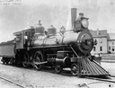
| Date: | 1896 |
|---|---|
| Description: | Wisconsin Central Railway's locomotive # 96 at the Waukesha depot. |
| Date: | 1896 |
|---|---|
| Description: | View of Washburn Observatory in the winter with snow. |
| Date: | 1896 |
|---|---|
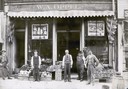
| Description: | Grocers standing in front of the W.A. Oppel Grocery located at 116 East Main Street. The five men are standing on the sidewalk among bine and crates displa... |
| Date: | 1896 |
|---|---|
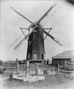
| Description: | Flour and grist mill built on Green Lake Prairie and later moved to Alto. It stood about 50 feet tall and 24 feet wide. |
| Date: | 1896 |
|---|---|
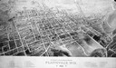
| Description: | Bird's-eye map of Platteville with twenty-two locations identified below image. Town square to left of center, behind Main Street. Area bordered by Lancast... |
| Date: | 1896 |
|---|---|
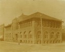
| Description: | Corner view from intersection towards the Ingram block, which contained the public library. |
| Date: | 1896 |
|---|---|
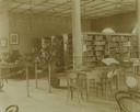
| Description: | Bookshelves and desks within the Eau Claire Public Library Reading Room. |
| Date: | 1896 |
|---|---|
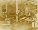
| Description: | Interior view of the Eau Claire Public Library. Tables and bookshelves in the public library reading room. |
| Date: | 1896 |
|---|---|
| Description: | Jefferson Street south from Doty Street with trees lining the street. |
| Date: | 1896 |
|---|---|
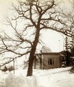
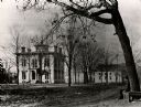
| Description: | The residence of O.S. Head. A man is sitting in the foreground on a wrap-around bench around a tree. |
| Date: | 1896 |
|---|---|
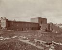
| Description: | View of the Cereal Mills Company building, with men and a horse-drawn buggy outside on of the buildings on the right. Another man is standing on the far le... |
| Date: | 1896 |
|---|---|
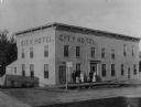
| Description: | Exterior view of the City Hotel with a group of people posed near its entrance. |
If you didn't find the material you searched for, our Library Reference Staff can help.
Call our reference desk at 608-264-6535 or email us at:
